

North Vancouver sells itself in about four seconds. Mountains behind you, ocean in front, downtown Vancouver twelve minutes away by boat, and a ski hill you can reach before the lifts start turning. People move here on the strength of a single visit.
The parts that decide whether you are still happy in year three are less photogenic: two bridges that have not gained a lane since 1968, a hospital carrying a catchment that reaches the Central Coast, and 50 per cent more rain than the airport gets, 20 kilometres away.
Here is the case both ways, with the numbers attached.
The short version
- The recreation case is real and measurable: 72 per cent of the District’s land is parks and open space once regional and provincial parks are counted, and three ski areas sit inside a half-hour drive.
- The commute is the honest problem. Traffic on the Ironworkers Memorial runs at 21,800 vehicles per lane per day, the heaviest load of any crossing in the region, and no new crossing is funded.
- Jobs are better than people assume, thanks to a federal shipbuilding programme and five working port terminals, though local jobs pay roughly $20,000 less than residents earn.
- Healthcare is the strongest in BC on paper and thin in practice: the lowest family-doctor waiting list of any health authority, and one hospital for 270,000 people.
- It rains here. At sea level North Vancouver gets about 1,830mm a year against 1,189mm at Vancouver airport, and above 200 metres it roughly doubles.
Two bridges and a boat
Everything about living on the North Shore comes back to how you get off it. There are exactly two road crossings, and a District staff report to council in April 2026 put hard numbers on what that means.
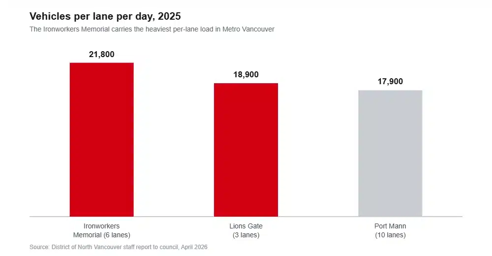
The Ironworkers Memorial carried 130,700 vehicles a day across six lanes in 2025, which works out at 21,800 per lane and makes it the most strained crossing in Metro Vancouver, ahead of the ten-lane Port Mann. It runs six per cent above 2019 levels. The Lions Gate carried 56,600 across three lanes and is six per cent below.
Mayor Mike Little put it plainly in that discussion: there has been no lane increase to the North Shore since 1968, and the population has more than doubled. Global News reported alongside the same report that the Province has no committed upgrades to Highway 1 serving the North Shore.
Where you live decides which bridge you are stuck with. Maplewood, Seymour, Blueridge, Deep Cove and Lynn Creek funnel to the Ironworkers. Norgate, Lions Gate Village, Edgemont and Pemberton Heights head for the Lions Gate. Lower Lonsdale skips both.
The boat, and the thing that actually changed
The SeaBus is the reason Lower Lonsdale works. Twelve minutes to Waterfront Station, every ten minutes through both peaks, landing you in a building that also holds the Expo Line, the Canada Line and the West Coast Express.
Rapid transit across Burrard Inlet has been studied since 2018 and is still a study. TransLink describes the Metrotown to North Shore bus rapid transit work as having preliminary funding, with an alignment decision targeted for 2027. Do not move here on the promise of SkyTrain.
What did arrive is smaller and real. On 7 September 2026 the R2 RapidBus extended from Phibbs Exchange through to Metrotown, a $6.8 million project delivered three months early, running every six or seven minutes at peak and giving a one-seat ride from Park Royal to Burnaby. For anyone in Lynn Creek or Lions Gate Village, that changed the daily maths more than any study has.
Work
The assumption is that North Vancouver is a bedroom community. Partly true, and less so than people think.
Seaspan’s Vancouver Shipyards sits on the Lonsdale waterfront with more than 2,500 employees, working through the National Shipbuilding Strategy. The joint support ship programme carries a $7 billion total project cost, with HMCS Protecteur launched in December 2024 and delivery planned for June 2027, and HMCS Preserver due to launch in December 2026. In March 2025 the yard also won a $3.15 billion contract to build a polar icebreaker. Call it a decade and more of well-paid trades work inside the municipality.
Five port terminals run along the same shoreline: Neptune, Cargill, Richardson, Lynnterm and Vancouver Wharves. Neptune alone handles up to 23.5 million tonnes a year, around the clock. The hospital employs roughly 1,500 people, the school district about 2,600, and Arc’teryx, A&W Canada and ICBC all keep offices or distribution here.
Now the honest part. The North Vancouver Chamber’s study of the 2021 census found the community is a net recipient of workers from Surrey, Coquitlam, Maple Ridge and Squamish, while its own higher-paid professionals commute out to Vancouver, Richmond and Burnaby. Jobs based in North Vancouver pay almost $20,000 a year less than the average income of North Vancouver residents. The jobs are real; they are often not the jobs the residents do.
Regional unemployment in the Mainland and Southwest region was 6.8 per cent in June 2026, against 6.5 per cent for the province.
Healthcare
The North Shore’s hospital is a recognised trauma centre and one of only five neurosurgery centres in British Columbia. Its new Paul Myers Tower opened on 9 March 2025: six storeys, 108 private rooms with ensuite washrooms and eight new operating theatres, at a capital cost around $325 million.
On family doctors, Vancouver Coastal Health has the shortest queue in the province. Its Health Connect Registry waiting list ran at 41 people per 1,000 population in July 2025, against 49 in Fraser, 58 in Northern, 88 in Interior and 133 on Vancouver Island. Read that as best of a difficult set rather than solved; roughly one in four British Columbians has no family doctor.
The caveat is structural. One hospital serves a catchment of more than 270,000 people, stretching up the Sea to Sky corridor, across the Sunshine Coast and out to the Central Coast, and Vancouver Coastal Health’s own planning documents describe demand as rising with growth and an ageing population.
Schools
One district covers both municipalities: about 16,000 students across 25 elementary schools, seven secondaries and an online programme, plus 13 independent schools in the same catchment.
The five-year capital plan is the clearest evidence of where pressure sits. It asks to take Carson Graham from 1,100 places to 1,400 and Sutherland from 950 to 1,150, to expand Lynnmour, Queensbury, Larson, Highlands, Seymour Heights and Ross Road, and to build a new elementary school. Westview already got a four-classroom mass timber addition worth 100 seats, finished in February 2026.
Those additions cluster in central North Vancouver and around Lynn Creek and Seymour, which is exactly where both municipalities are directing housing. Enrolment across the district has been roughly flat, so this is capacity moving to follow growth rather than a district filling up everywhere.
The case for, and it is a strong one
The District’s own parks plan counts 3,158.8 hectares of District parkland, 19 per cent of its area, and reckons 72 per cent of its total land is parks and open space once regional and provincial parks are added. Almost three-quarters of the municipality is not built on.
Lynn Canyon Park is free, has been since it opened in 1912, and its suspension bridge hangs 50 metres above the creek. Mount Seymour Provincial Park has been there since 1936. The Baden-Powell trail runs from Deep Cove across the whole North Shore to Horseshoe Bay. Grouse and Mount Seymour are both in the District, with Cypress next door in West Vancouver.
One caution on the skiing, because it gets oversold. These are low coastal mountains. Mount Seymour’s published 2026 to 2027 winter season runs 11 December to 4 April, about sixteen weeks, and in 2025 all three local hills opened later than the year before after atmospheric rivers and record warmth into mid-December. Twenty minutes from your door is the selling point. Reliable snow is not.
The rain, which nobody puts in the brochure
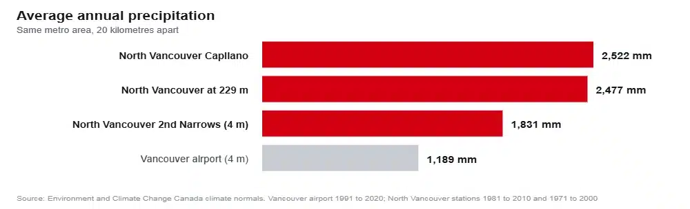
At the 2nd Narrows station, four metres above sea level, North Vancouver averages 1,830.8mm of precipitation a year. Vancouver airport, on the same coast about 20 kilometres away, averages 1,189mm. Call that 54 per cent more, at the same elevation.
Climb the hill and it gets steeper. The Capilano station records 2,522mm across 178 days with precipitation. A station at 229 metres on the Deep Cove side records 2,476.8mm. The local rule of thumb is roughly 100mm of extra rain for every 100 metres of elevation, and it is why Lynn Valley, Edgemont and Deep Cove feel meaningfully wetter than Lonsdale, which feels wetter than Kitsilano.
No one should be talked out of moving here by rainfall. Everybody should know the number before they sign, because it is the single most common regret people voice about the North Shore.
Growth arriving on the same two bridges
Metro Vancouver’s regional strategy projects the North Shore going from 207,600 residents in 2020 to 271,000 by 2050. Sixty-three thousand more people and 38,400 more homes, with no new crossing funded.
Both municipalities are under provincial housing target orders. The City must deliver 3,320 net new units over five years and hit 94 per cent of its year one target with 547 completions. The District must deliver 2,838 and reported 500 net new units in its first year against a target of 499.
Construction tells a slower story. Combined housing starts across both municipalities in 2025 came to 565, of which 93 per cent of the City’s were apartments. Targets are measured in completions and apartments take years, so this is a pipeline question rather than a failure, but it is a real one.
One structural quirk is worth knowing if you follow housing policy. The District’s small-scale multi-unit housing rules exempt any parcel sitting inside its wildfire, creek or slope hazard development permit areas. Geography physically removes land from provincial upzoning here in a way it does not in Surrey or Burnaby. And because the North Shore has no rail transit, its transit-oriented designations at Lonsdale Quay, Phibbs and Capilano University carry the lower bus-exchange density tier rather than the SkyTrain one.
The rest of the honest list
Slope hazard is genuine on the escarpment edges. A 2010 engineering review assessed nine areas after the 2005 Berkley landslide, and the practical result is development permit areas over parts of Blueridge, Riverside, Westlynn, Pemberton Heights and the Capilano and Mosquito Creek escarpments, where building can require a geotechnical report.
Wildfire is on the City’s radar too. Its community wildfire protection plan flags limited access and egress for homes at the top of Mackay Avenue, between Heywood Park and Mosquito Creek Park, and between Westmoreland Crescent and Alden Lane, noting many houses sit on single access roads.
The industrial waterfront pays for a lot of the good jobs and also means rail movements, truck traffic and dust concerns for the neighbourhoods closest to it. Both things are true at once, and Lower Lonsdale and Moodyville live with both.
So, is it a good place to live?
Yes, decisively, if you work on the North Shore, or downtown within reach of the SeaBus, or from home. The parks, the schools, the hospital and the sheer amount of undeveloped land add up to something few places in Metro Vancouver can match.
Think harder if your job is in Burnaby, Richmond or the Fraser Valley and you will be driving to it. The bridge data is not a complaint about bad days; it is the ordinary condition of the crossing, and nothing funded will change it this decade.
Frequently asked questions
Is North Vancouver worth the price?
For proximity to the outdoors, few places in Canada compete. The honest counterweight is that local jobs pay about $20,000 less than residents earn, so many households are buying North Vancouver and commuting out of it to afford it.
How bad is the commute from North Vancouver?
Depends entirely on direction. The SeaBus to downtown is twelve minutes and unaffected by traffic. Driving east or south across the Ironworkers puts you on the most heavily loaded crossing in the region, where a single incident can gridlock the North Shore for hours.
Does it rain more in North Vancouver than Vancouver?
Substantially. About 1,830mm a year at sea level against 1,189mm at Vancouver airport, rising to roughly 2,500mm on the higher slopes. Add about 100mm for every 100 metres you climb.
Is there a hospital in North Vancouver?
Yes. Lions Gate Hospital is a trauma centre and one of five neurosurgery centres in BC, with a new six-storey tower opened in March 2025. It is the only hospital for a catchment of more than 270,000 people.
Is SkyTrain coming to the North Shore?
Nothing is funded for construction. An alignment decision on Burrard Inlet rapid transit is targeted for 2027. The concrete improvement already delivered is the R2 RapidBus extension to Metrotown.
How we put this together
Figures come from the two municipalities, Metro Vancouver, TransLink, Vancouver Coastal Health, the Province of British Columbia, Environment and Climate Change Canada, CMHC, WorkBC, Public Services and Procurement Canada, the Vancouver Fraser Port Authority and School District 44, linked where they appear.
Four gaps we would rather name. No North Vancouver weather station appears in the current 1991 to 2020 climate normals, so the local rainfall figures come from the 1981 to 2010 and 1971 to 2000 periods and are compared with the airport’s newer set. Emergency wait times for Lions Gate are published live rather than as a historical series, so no average appears here. Vancouver Coastal’s family doctor figures come from freedom of information data published by an independent analyst, because the Province publishes no regional breakdown. And the census commuting data behind the jobs section was collected in 2021, when working from home ran at several times its usual rate.
Sources
- District of North Vancouver traffic volume report, April 2026, as reported
- TransLink, R2 Marine Willingdon RapidBus
- TransLink, SeaBus schedules
- Government of Canada, polar icebreaker contract to Vancouver Shipyards
- National Defence, joint support ship project
- North Vancouver Chamber, 2021 census economic study
- Province of British Columbia, Paul Myers Tower opening
- Vancouver Coastal Health, Lions Gate Hospital health vision
- BC Health Data, primary care attachment
- School District 44, five-year capital plan
- District of North Vancouver, parks and open space strategic plan
- Environment and Climate Change Canada, North Vancouver climate normals
- Metro Vancouver, Metro 2050 projections
- Province of British Columbia, housing target orders
- District of North Vancouver, provincial housing legislation fact sheet
- WorkBC, labour market monthly update
Across the boundary to the west, we have done the same exercise for West Vancouver, which shares the bridges and the wildfire maps and very little else.
Still weighing it up? Our area guide goes through what each North Vancouver neighbourhood is actually like, the cost breakdown prices out rent, tax and utilities, and the crime numbers separate the City from the District. When the decision is made, tell us where you are moving from.
