

Start with a warning about the map. Coquitlam adopted an Interim Official Community Plan on 27 April 2026, replacing a plan that had been in force since 2001. It cut policies by 70 per cent, reduced 55 land use designations to 18 and replaced more than 60 maps with 19. A full rewrite begins in 2027. Anything written about Coquitlam’s area plans before mid-2026 is describing a document that no longer governs.
Second warning, about the name. Half the places people call Coquitlam are not in Coquitlam. Klahanie and Newport Village are in Port Moody. Citadel Heights and Riverwood are in Port Coquitlam. Three separate cities share the Tri-Cities label, three separate councils set three separate tax rates, and only one of them has SkyTrain stations of its own.
Third, the thing nobody selling you a house will say out loud: no primary source publishes prices by neighbourhood here. Greater Vancouver Realtors reports Coquitlam, Port Coquitlam and Port Moody as three whole municipalities and goes no finer. Every “average price on Burke Mountain” you find online is an unpublished extract from a brokerage’s private system, unaudited and often built on single-digit monthly sale counts. In August 2026 the entire city of Coquitlam recorded 42 sales. What follows is character, planning, transit and trade-offs, because those can actually be sourced.
Three naming systems, none of which match
Coquitlam runs three parallel geographies and they disagree with each other.
The statutory one lives inside the Interim OCP as eight Neighbourhood Plans, covering places like Maillardville, Austin Heights, Burquitlam-Lougheed and the four creek-named plan areas on Burke Mountain. The demographic one is a set of 13 Community Profile areas the City uses when it publishes statistics: Austin Heights, Cape Horn, Cariboo/Burquitlam, Central Coquitlam, Eagle Ridge, Hockaday Nestor, Maillardville, Mayfair/Pacific Reach, Northeast Coquitlam, Ranch Park, River Heights, Town Centre and Westwood Plateau. The third is what people and listings actually say.
Notice what is missing from the official lists. There is no Burke Mountain profile area; the City calls it Northeast Coquitlam. Como Lake is a lake, a park and an avenue, not a neighbourhood designation. Harbour Chines, Chineside, River Springs and Coquitlam West exist only in MLS and in conversation. Cape Horn is the odd one out among those names, because it genuinely is a City profile area.
A caution on the profiles. They are useful for character, but they were published in 2019 using 2016 Census data, so treat the numbers below as a picture of the neighbourhood a decade ago rather than today.
City Centre
The densest and fastest-changing part of Coquitlam, and the only place in the Tri-Cities where you can live without a car without thinking hard about it. Three of the six Evergreen Line stations sit here: Coquitlam Central, Lincoln and Lafarge Lake–Douglas. Coquitlam Central also has a West Coast Express platform.
The area held 31,380 residents in 2016, up from 5,061 in 1981. The City Centre Area Plan approved in November 2020 aims for 55,000 over 25 years. Behind that number sits a proposed redevelopment of the Coquitlam Centre mall site, roughly 60 acres, with the first phase anchored on Lincoln Station.
Best for commuters, first-time buyers and anyone who wants a grocery store, a library, a rec centre and a train within a few blocks. The trade-off: you are buying into a construction site that has 20 years left to run, and almost everything for sale is an apartment.
Burquitlam
Officially Cariboo/Burquitlam, in MLS listings usually Coquitlam West, and in practice the neighbourhood being rewritten faster than anywhere else in the region. Burquitlam Station opened in 2016 and put the whole area inside a provincially designated transit-oriented area, where the minimum height a city must permit within 200 metres of a station is 20 storeys.
The pace is easy to underestimate. Council adopted the transit-oriented rezoning package on 27 May 2026 and voted on 6 July 2026 to rezone 374 properties from R-3 to R-1. Next to the station, a six-tower proposal at Burquitlam Plaza would add roughly 2,175 rental homes on its own.
Best for buyers who want a 25-minute ride to Commercial–Broadway and can live with cranes. The trade-off: if you buy a single-family house here, understand that your block’s land-use rules are actively being changed around you.
Maillardville
The oldest identity in the city and the most distinctive. French-Canadian sawmill workers were recruited here for the Canadian Western Lumber Company more than a century ago, and the neighbourhood is named after Father Edmond Maillard. Festival du Bois still runs every spring, described by the City as the largest francophone festival on Canada’s West Coast.
Physically it is 277 hectares holding about 8,590 people in 2016, with a housing mix unusual for Coquitlam: roughly 39 per cent single-family and 37 per cent low-rise apartment, so the streets have a genuine mix rather than a monoculture. Language data from the same profile shows Mandarin and Korean both climbing since 2006.
The heritage is documented but not legally protected. Coquitlam has a heritage management strategy in progress and no heritage conservation area covering Maillardville, while the Interim OCP increases permitted density west of Lebleu Street.
Best for buyers who want character, older stock and a walk to Braid Station or the Fraser. The trade-off: the character has no legal defence, and the plan invites more height.
Austin Heights and Central Coquitlam
Austin Heights is a commercial spine with a neighbourhood wrapped around it, and the City’s profile area for it is tiny, just 66 hectares. Austin Avenue and Como Lake Avenue are the two streets Coquitlam has singled out as growth “corridors” alongside its transit-oriented areas, which means the low-rise strip along Austin is on the list to change.
Central Coquitlam behind it is what most people picture when they think of established Coquitlam: post-war and 1960s detached houses, Mundy Park at the centre of it, Como Lake a short walk away, and Dr. Charles Best Secondary nearby. Central Coquitlam is quieter than the numbers suggest and closer to everything than the map suggests.
Best for families who want a yard, mature trees and a five-minute drive to the SkyTrain rather than a five-minute walk. The trade-off: bus service is fine rather than good, and the arterials are getting busier.
Westwood Plateau
The hillside subdivision that defines suburban Coquitlam, running from about 60 metres of elevation to 400. It held 19,775 residents across 2,309 hectares in 2016 and, unusually for this city, barely changed between 2011 and 2016. The build-out is essentially finished, which is the whole appeal.
The housing skews to detached houses and townhouses from the 1990s and 2000s, the age profile skews to people in their thirties and forties, and the household incomes in the 2016 profile ran well above the Coquitlam median. École Panorama Heights runs early French Immersion here.
Best for families who want a big house, quiet streets and forest at the end of the cul-de-sac. The trade-off: it is a car neighbourhood. Buses run roughly every half hour off peak, TransLink’s area transport plan for the northeast sector dates from 2013 to 2015 and does not mention Westwood Plateau at all, and there is no funded rapid transit up the hill in any plan that exists.
Burke Mountain
Officially Northeast Coquitlam, and the largest profile area in the city at 6,096 hectares, most of it park and watershed. It gained almost 6,500 residents between 2011 and 2016, more than doubling. Practically everything here was built this century, on the statutory plan areas named after creeks: Lower Hyde Creek, Upper Hyde Creek, Smiling Creek and Partington Creek, with Hazel-Coy in planning for up to 950 more homes.
The honest version of Burke Mountain is that the amenities are under construction, not built. Burke Mountain Village is a 39-acre commercial centre with around 120,000 square feet of retail including a grocery store, a public plaza and a village greenway. The community centre and the village park are being built now. The Province announced a combined middle and secondary school worth roughly $160 million and 1,000 seats in 2024, because the elementary schools filled faster than anyone planned for.
Best for families who want the newest housing stock in the Tri-Cities and mountain trails from the driveway. The trade-off: you drive for everything until the village opens, the commute down the hill is the daily reality, and the City’s own wildfire resiliency plan names Burke Mountain as a wildland-urban interface neighbourhood.
Fraser Mills and səmiq̓ʷəʔelə
Two places that will matter later and are worth knowing about now.
Fraser Mills is a 96-acre waterfront redevelopment on the Fraser in southwest Coquitlam, on the old mill site, being built by Beedie. It includes a City community centre with a pool, waterfront parks and public art, with the community centre design revealed in July 2026. The Interim OCP names it as a long-term development hub alongside Poirier, Lafarge Lake–Douglas, Lincoln and Partington Creek.
səmiq̓ʷəʔelə is the 244-acre site in southeast Coquitlam formerly called Riverview, renamed in 2021. The name means “place of the great blue heron” in hən̓q̓əmin̓əm̓. BC Housing manages the site in partnership with kʷikʷəƛ̓əm, whose stewardship of the area goes back more than 4,000 years, and it still hosts provincial mental health and substance use programmes. Master planning has been running since 2021. No master plan has been published, so anyone telling you what is going to be built there is guessing.
Port Moody
A separate city of about 33,500 people with its own police department, its own tax rate and, since 2026, its own new official community plan setting out 13 neighbourhood plan areas.
Moody Centre is the interesting one. It has a SkyTrain station and a West Coast Express platform, the brewery cluster people call Brewers Row, and a transit-oriented development area with a baseline maximum of 26 storeys. Rocky Point Park and the Shoreline Trail are a short walk from it. Inlet Centre is the second station area and contains Newport Village along with Coronation Park, which is being redeveloped.
Above the highway sit Heritage Mountain, Heritage Woods, Twin Creeks, Mountain Meadows and Noons Creek, Port Moody’s answer to Westwood Plateau: newer detached and townhouse stock, forested, and a drive from the train. Port Moody Secondary is the only International Baccalaureate school in School District 43, which is a real reason some families choose this city over Coquitlam.
Best for people who want a walkable waterfront town with SkyTrain and the lowest crime rate of any Metro Vancouver city of size. The trade-off: it is the most expensive of the three on almost every measure, with an August 2026 detached benchmark of $1,962,100 against Coquitlam’s $1,599,100.
Port Coquitlam
The value option, and not by a small margin. Port Coquitlam’s detached benchmark in August 2026 was $1,243,800, some $355,300 below Coquitlam’s, which is the sharpest price step anywhere along this corridor.
Its official community plan dates from 2013 and names Lincoln Park and Mary Hill as the established 1950s-onward areas, Riverwood and Citadel Heights as the 1980s and 1990s subdivisions, and Dominion and Fremont as the parts currently building out. Downtown along Shaughnessy is a genuine main street with a farmers market and a rec complex, which is more than most suburbs of this size manage.
No SkyTrain station sits inside its boundary. There is a West Coast Express station, the R3 RapidBus runs through it, and Coquitlam Central is close enough that its 800-metre transit radius crosses the boundary.
Best for buyers who want a detached house and are willing to trade a SkyTrain walk for it. The trade-off: the trains only run one direction at peak, so a non-standard schedule means driving or a bus to Coquitlam Central.
Where the growth is going, and in what form
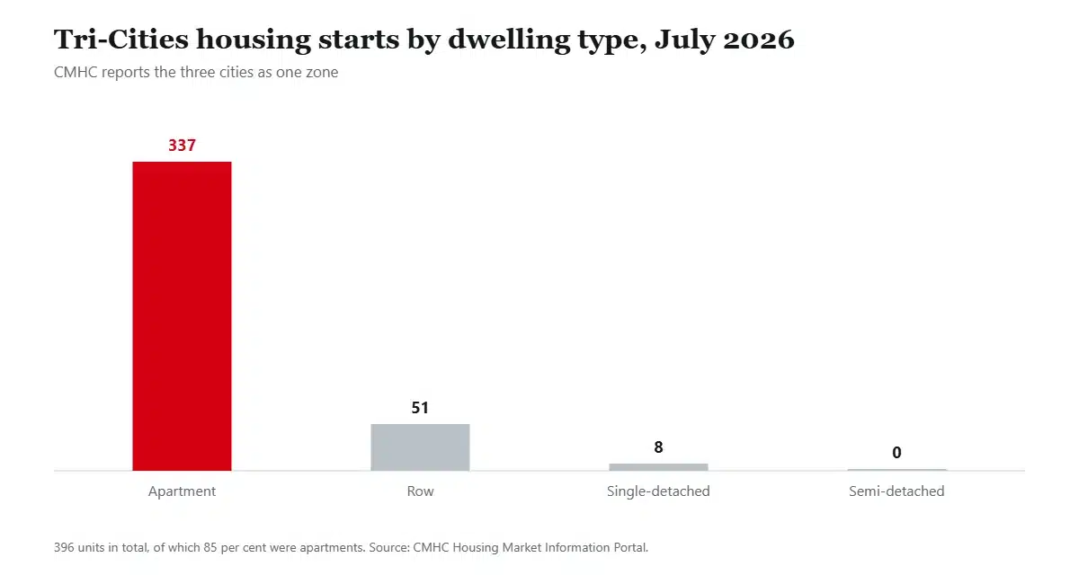
That chart is the Tri-Cities housing story in one line. Of 396 units started across all three cities in July 2026, 337 were apartments and eight were single-detached houses. If you want a new detached home here, you are looking at Burke Mountain or nothing.
Where those apartments go is set by provincial transit-oriented area rules rather than by the city. Coquitlam’s designation bylaw covers eight stations, and four of them are not in Coquitlam: Braid is in New Westminster, Lougheed Town Centre is in Burnaby, and Moody Centre and Inlet Centre are in Port Moody. The 800-metre radius is drawn from the platform, not the municipal line.
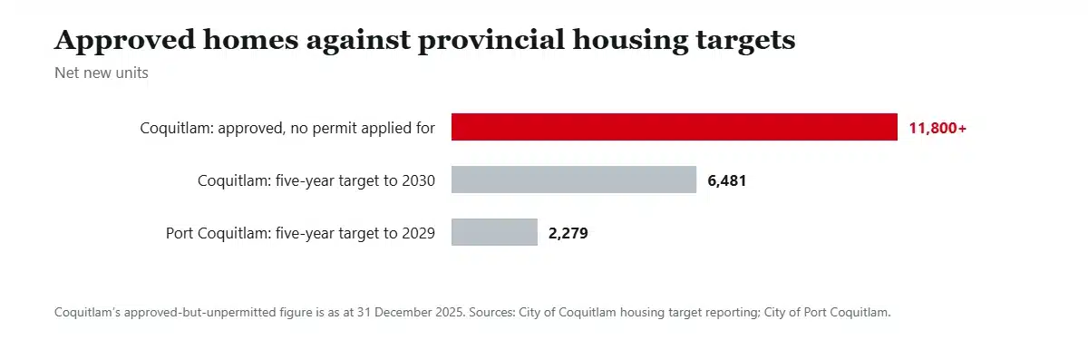
Approvals are not the constraint. As at 31 December 2025, Coquitlam had more than 11,800 approved housing units that had not yet applied for a building permit, against a five-year provincial target of 6,481. It delivered 1,032 net new units in the first six months of the target period, beating the whole first-year figure of 972 halfway through.
Transit, honestly
The Evergreen Extension opened on 2 December 2016 with six stations. Four are in Coquitlam and two are in Port Moody, so the line that everyone credits to Coquitlam is really a Tri-Cities line. Lincoln is the station usually left off lists, and it is the one serving the mall site.
Two details matter more than the headline. The Millennium Line does not reach Waterfront, so every downtown trip involves a transfer to the Expo Line at Commercial–Broadway. And the West Coast Express, which is faster to Waterfront at about 30 minutes from Coquitlam Central, runs five trains west in the morning and five east in the afternoon, weekdays only, with nothing in reverse and nothing at weekends.
The R3 Lougheed RapidBus is often listed as a Coquitlam service. It runs east to Maple Ridge, and exactly one of its eight stops is in Coquitlam: the terminus at Coquitlam Central.
Everywhere uphill is local bus territory. Burke Mountain, Westwood Plateau, upper Eagle Ridge, Heritage Mountain and Heritage Woods are car-dependent in practice, and no funded project changes that.
Schools
School District 43 covers all three cities plus Anmore and Belcarra, with about 32,000 students in 70 schools, which its own page describes as the third largest district in British Columbia. The district is also the region’s largest employer.
Early French Immersion runs at 11 elementary schools across the three cities, including École Panorama Heights on Westwood Plateau, École Coquitlam River near Burke Mountain, École Glenayre in Port Moody and École Mary Hill in Port Coquitlam, feeding middle schools like École Banting and École Maple Creek and secondaries at École Dr. Charles Best and École Riverside. Late immersion entry runs from grade 6 at École Citadel, École Montgomery and École Moody.
The capital plan shows the pressure clearly. A 2023–24 submission asked for more than $1 billion, including new schools at Partington Creek and a Northeast Coquitlam middle school, replacements for Montgomery, Maple Creek, Como Lake, Nestor and Cedar Drive, classroom additions at twelve schools and seismic work at nine. Total enrolment is not the driver. Where students live is.
Hazards worth knowing before you choose a street
Bears first, because this is the region’s clearest wildlife story. The Conservation Officer Service logged 2,416 black bear conflict calls across the three cities in 2022, roughly one in six of all reported black bear conflicts in the province. Coquitlam’s attractant rules require garbage and green carts stored in a garage or wildlife-resistant enclosure, bird feeders suspended and fruit harvested, with fines up to $500.
Wildfire next. Coquitlam’s Community Wildfire Resiliency Plan names Burke Mountain, Eagle Mountain, land near Pinecone Burke Provincial Park, the Coquitlam Watershed and areas next to Mundy Park as wildland-urban interface. The same plan notes that hydrant coverage does not reach a few isolated structures on Quarry Road, and that hydrant lays are long on Quarry Road and around Partington.
Then water. Coquitlam monitors four rivers, the Brunette, Coquitlam, Pitt and Fraser, with dikes and pump stations protecting low-lying property. Flood construction levels near the Pitt and Fraser confluence assume a metre of sea level rise by 2100 and two metres by 2200, and the City has 200-year and Year 2200 floodplain mapping. The City does not name neighbourhoods as flood-prone on its public pages, so check the flood extents map for the specific address rather than trusting a general claim about an area.
Finally slope. Steep-slope development permit requirements sit in the Interim OCP schedules and apply across the hillside neighbourhoods, which is a real cost on a pretty lot.
A word on timing, if you need to sell first
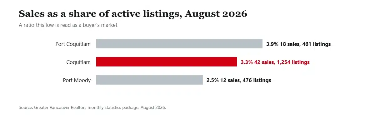
Coquitlam recorded 42 sales against 1,254 active listings in August 2026, a sales-to-active ratio of 3.3 per cent. Port Coquitlam managed 3.9 per cent and Port Moody 2.5 per cent. Composite benchmark prices fell between 4.3 and 8.5 per cent over the year across the three cities.
For anyone buying and selling in the same market that cuts both ways, but it does mean a sale here currently takes time. Plan your move dates with slack in them.
Frequently asked questions
What is the nicest area of Coquitlam?
Depends entirely on what you are optimising for. Newest housing and trails point to Burke Mountain, an established family neighbourhood to Westwood Plateau or Central Coquitlam, walkability and transit to City Centre, character and older stock to Maillardville, and value to Port Coquitlam next door.
Is Burke Mountain a good place to live?
For families who want new build and forest, yes, with one honest caveat: the grocery store, the community centre and the village core are under construction rather than open, so it is a driving neighbourhood until they finish.
Is Klahanie in Coquitlam?
No. Klahanie is in Port Moody, within the Moody Centre area, and Newport Village is also Port Moody, in Inlet Centre. Different city, different council, different property tax rate.
How many SkyTrain stations does Coquitlam have?
Four: Burquitlam, Coquitlam Central, Lincoln and Lafarge Lake–Douglas. The Evergreen Extension has six, but Moody Centre and Inlet Centre are in Port Moody.
Which Tri-Cities neighbourhood is cheapest?
Nobody publishes prices below the municipal level, so a neighbourhood-level answer would be invented. What is published is that Port Coquitlam is the cheapest of the three cities on every property type, with an August 2026 apartment benchmark of $558,300 against Coquitlam’s $646,100 and Port Moody’s $680,200.
How we put this together
Area names and planning status come from the City of Coquitlam’s Interim Official Community Plan and Community Profiles, the City of Port Moody’s 2050 OCP and the City of Port Coquitlam’s OCP. Prices come from Greater Vancouver Realtors, housing starts from CMHC, transit from TransLink, schools from School District 43, and hazard information from the cities’ own wildfire, floodplain and wildlife pages.
Three things we deliberately left out. No neighbourhood-level prices appear here, because no primary source publishes them. We have not described what will be built at səmiq̓ʷəʔelə, because no master plan has been published. And we have not repeated the widely circulated claim that the hillside neighbourhoods have single-access-road evacuation problems, because we could not find a City or fire department source that says so.
Sources
- City of Coquitlam, Interim Official Community Plan, Bylaw 5511, 2026
- City of Coquitlam, Community Profile and Planning Areas map
- City of Coquitlam, transit-oriented areas
- City of Coquitlam, housing target order reporting
- City of Coquitlam, Burke Mountain Village
- City of Coquitlam, Fraser Mills development
- City of Coquitlam, wildlife management
- City of Coquitlam, wildland-urban interface areas
- City of Coquitlam, floodplain and dikes
- BC Housing, səmiq̓ʷəʔelə
- City of Port Moody, 2050 Official Community Plan, neighbourhood plan areas
- City of Port Coquitlam, Official Community Plan, Bylaw 3838
- School District 43, our region
- TransLink, West Coast Express
- Greater Vancouver Realtors MLS Home Price Index statistics
Two of the eight stations Coquitlam plans around sit in other cities entirely, and Braid is one of them. Our guide to New Westminster covers that side of the boundary.
Narrowed it down to a shortlist? Our cost breakdown prices out tax, utilities and the commute city by city, the crime numbers separate the three police services properly, and the wider case for and against weighs the whole thing up. When you have picked a street, tell us where you are moving from.
