

Burnaby does not have one downtown the way most cities do. It has a downtown at Metrotown, three more town centres at Brentwood, Lougheed and Edmonds, thirteen smaller villages strung along the SkyTrain lines, and between all of that, a lot of quiet hillside streets that have barely changed in forty years. The city’s new Official Community Plan, adopted on 9 December 2025, spells that structure out in writing for the first time in a generation, and it is the most useful map you can have when picking where to live here.
So this guide is organised the way the city is. Metrotown and its surroundings first, then North Burnaby along Hastings and Willingdon, then the northeast around Lougheed and the mountain, then the southeast around Edmonds, and finally the green middle around Deer Lake and Burnaby Lake. Each entry says who the area suits, what the transit is really like, what the housing stock looks like and what the trade-off is. Prices and rents come from Greater Vancouver Realtors and CMHC, not from a listing site.
Already know which part of Burnaby you are heading to?
Secure Moving’s head office is on Manor Street in Burnaby, and our crews handle the towers at Metrotown and Brentwood, the strata rules that come with them, and the hillside driveways up Capitol Hill and Burnaby Mountain every week. Rates, crew sizes and what a typical move costs by home size are on our Burnaby movers page.
How Burnaby is laid out
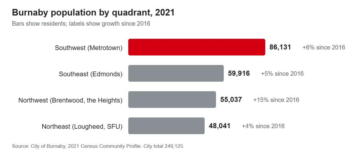
The City counts its population in four quadrants, and on the 2021 census they were nowhere near equal. The southwest, which holds Metrotown, had 86,131 people. The southeast, with Edmonds, had 59,916. The northwest, with Brentwood and the Heights, had 55,037 and was growing fastest at 15 per cent over five years. The northeast, with Lougheed and Simon Fraser University, had 48,041.
Two things about the whole city shape every neighbourhood choice. First, it is an apartment city: 29 per cent of homes are in buildings of five storeys or more, another 24 per cent in low-rises, and only 19 per cent are detached houses. Four in ten households rent. Second, it is a SkyTrain city. Eleven stations sit inside Burnaby on the Expo and Millennium lines, and the new plan pushes the most growth to the land around them. Under the zoning bylaw that took effect on 1 July 2026, transit-oriented areas around stations allow eight to twenty storeys with no parking minimums, and every ordinary residential lot can now hold three to six homes.
The plan’s own hierarchy is worth knowing because it tells you where the cranes will be for the next twenty-five years. Metrotown is the Downtown. Brentwood, Lougheed and Edmonds are Town Centres. Bainbridge, Broadview, Garden Village, the Heights, Holdom, Lake City, Lochdale and Royal Oak are Rapid Transit Urban Villages. Burnaby Mountain, Cascade Heights, Montecito, Deer Lake and Sixth Street are Urban Villages. Everything else is meant to change slowly.
What homes and rents actually cost
Nobody publishes benchmark prices by Burnaby neighbourhood. Greater Vancouver Realtors splits the city into three realtor areas, Burnaby East, North and South, which do not line up with the City’s quadrants, and that is as fine as the public data gets. In August 2026 all three were down on the year.
| Area (GVR) | Detached | Townhouse | Apartment | All types, 1-yr |
|---|---|---|---|---|
| Burnaby South (Metrotown, South Slope, Big Bend) | $1,887,800 | $933,600 | $731,500 | −6.9% |
| Burnaby North (Heights, Brentwood, Lougheed, the mountain) | $1,816,500 | $888,200 | $669,700 | −7.8% |
| Burnaby East (Edmonds, East Burnaby, Cariboo) | $1,694,900 | $852,700 | $707,600 | −10.2% |
MLS Home Price Index benchmarks, August 2026. Source: Greater Vancouver Realtors. Burnaby recorded 43 detached, 39 townhouse and 152 apartment sales that month.
BC Assessment’s 2026 roll tells the same story from a different angle: a typical Burnaby house was assessed at $1,959,000 and a typical strata unit at $706,000, both down four per cent on the year. The gap between a house and an apartment is more than $1.2 million almost everywhere in the city, which is why the real decision for most people is not which neighbourhood but which building type, and then which neighbourhood has that building type near a station.
Rents are where the neighbourhoods separate. CMHC surveys purpose-built rental buildings every October, and its figures are what tenants pay, long-term tenants included, so they run well below what you will see on a listing site.
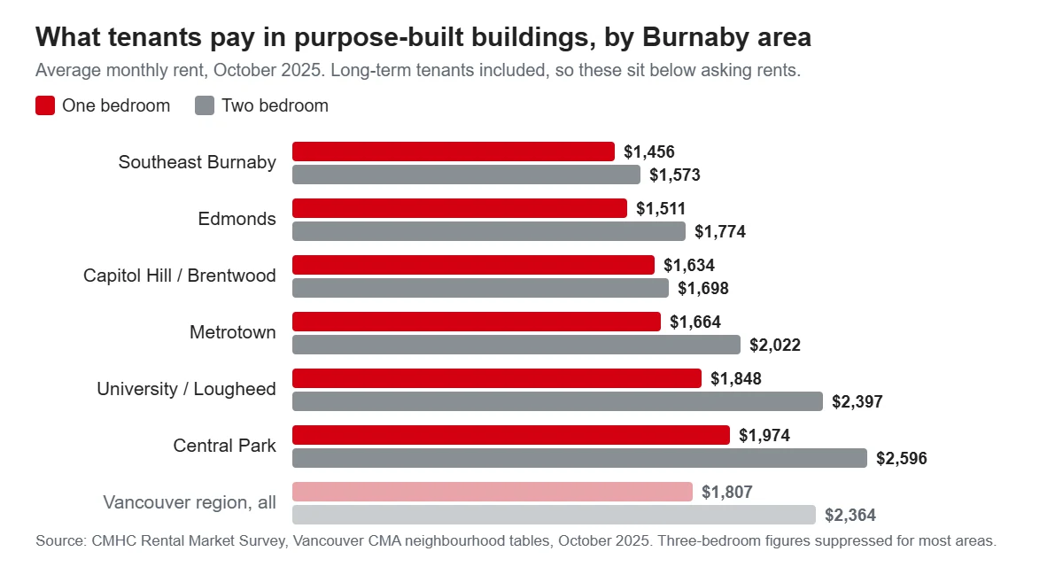
Southeast Burnaby and Edmonds are the cheapest purpose-built stock in the city at $1,456 and $1,511 for a one-bedroom. The Central Park zone, the older tower belt on the Vancouver side of Metrotown, is the most expensive at $1,974, and a two-bedroom there averaged $2,596. Asking rents on new leases are another matter: Rentals.ca put Burnaby’s average asking rent at $2,498 in its September 2026 report. Vacancy has loosened, though. CMHC recorded 5.6 per cent in North Burnaby and 3.6 per cent in the southeast, and singled out the new supply around Brentwood, Edmonds and Metrotown as the reason.
Metrotown and the southwest
Metrotown
The Downtown in the City’s own language, and it behaves like one. Two Expo Line stations, Patterson and Metrotown, sit inside the area with Royal Oak on its eastern edge, and Waterfront is twenty minutes away without a transfer. Metropolis at Metrotown is the largest mall in British Columbia at about 1.78 million square feet of retail. Crystal Mall across Kingsway is the Chinese-market counterpart with around 250 stores. Central Park is 86 hectares of forest, tennis courts, a pitch-and-putt and Swangard Stadium, and Bonsor Recreation Complex and the Bob Prittie Metrotown library are both a short walk from the station.
The housing is towers, older and newer. The area built its first generation of concrete apartments in the 1970s and 1980s, and much of that stock is now being replaced, which is the story that follows Metrotown around. The City’s Tenant Protection Bylaw, in force since 1 July 2026, requires replacement rental homes and gives displaced tenants the right to return at their old rent. By the City’s count 91 households had already moved back into four finished projects by May 2026, and roughly 1,900 rental homes were in some stage of redevelopment. If you are renting an older building here, read the rezoning notices on the lobby door.
One more thing to know. The Burnaby RCMP reports crime by four internal districts, and the southwest district, whose community police office is on Kingsborough Street beside the mall, records about half of all offences in the city every quarter, 1,913 of 3,637 in the first three months of 2026. The bulk of it is property crime and shoplifting around the retail, not violence, which fell 12 per cent year over year. Our separate look at the Burnaby crime numbers goes through this properly.
Best for: people who want a car-free life with the shortest commute in Burnaby and do not mind living inside a construction zone for a decade. Ivanhoé Cambridge’s concept for redeveloping the mall lands itself runs to 2054.
Central Park and Garden Village
West of the mall toward Boundary Road, the towers thin out into a mix of 1970s low-rises, townhouse complexes and single-family streets. Garden Village is one of the plan’s Rapid Transit Urban Villages, so expect mid-rise infill along Kingsway and around Patterson station over time. Moscrop Secondary, one of the district’s three French Immersion high schools, serves this side.
Best for: renters who want Metrotown’s transit without living in the middle of it, and families who want a school with a French Immersion track.
South Slope and Suncrest
The hill that falls away from Kingsway and Imperial Street toward the Fraser River, and the closest thing the southwest has to a classic single-family neighbourhood. Lots are wide, streets are quiet, and the upper streets look south over the river to Richmond and Delta. Burnaby South Secondary on Rumble Street is one of two district schools offering the AP Capstone diploma, and it houses the 600-seat Michael J. Fox Theatre. Transit is bus-based: the frequent 49 runs along Imperial to Metrotown station, and everything else is a walk uphill.
Best for: buyers who want a house or a duplex with a yard and can accept a bus ride to the SkyTrain. Those wide lots can now carry up to six homes under the new zoning, so the streetscape is going to change.
Big Bend
Worth a paragraph because people search for it, but it is not really a place to live. The flat land in the river’s bend is Burnaby’s last farmland, a big-box retail strip at Market Crossing, industrial parks and the Fraser Foreshore Park with its four-kilometre riverside path. Burnaby’s own plan names Big Bend and the Still Creek corridor as its two major flood-risk areas, and about 800 hectares of the south slope’s foot lie in the diked floodplain along seven kilometres of the North Arm. Live above it, walk in it.
North Burnaby: the Heights, Capitol Hill and Brentwood
Burnaby Heights
Hastings Street from Boundary Road to Gamma Avenue is the most complete main street in Burnaby, roughly 330 shops and services along a dozen blocks, with the Italian delis and bakeries that give the area its reputation. The streets north and south of it are 1940s and 1950s houses on a proper grid, with Confederation Park, the Eileen Dailly pool and McGill library at the west end. Transit changed for the better on 7 September 2026, when the R2 RapidBus was extended from the North Shore down Hastings and Willingdon to Metrotown, running every six to seven minutes at peak. The R5 already ran along Hastings to downtown and SFU.
The plan calls the Heights a Rapid Transit Urban Village, so Hastings itself will get taller, but the grid behind it is meant to stay low.
Best for: people who want to walk to a real high street and are happy on a bus rather than a train. The new Burnaby North Secondary, built for 1,800 students with the AP Capstone programme, serves the area.
Capitol Hill
The hill north of Hastings climbs to 203 metres, and the top streets have views across Burrard Inlet to the North Shore mountains that people pay a lot for. The houses are a mix of original post-war bungalows and large rebuilds, the streets are steep enough that a moving truck needs a plan, and the amenities are the Heights below.
The thing to check before buying is the sky. Nav Canada changed the arrival paths into YVR in November 2025 and February 2026, and Capitol Hill, Lochdale, Lougheed and East Burnaby all sit under the new routes. Residents measured noise at 63.5 to 66.6 decibels against a forecast of 55, and in June 2026 the City formally asked for an independent review of the impact. It may get fixed. Assume for now that it has not.
Best for: buyers who want a view and a quiet street and will spend evenings outside to test the flight noise first.
Brentwood
The fastest-changing square kilometre in the province. Two Gilmore Place, finished in 2024, is 64 storeys and the tallest building in British Columbia. The Amazing Brentwood has three towers up with more to come, and Willingdon Lands, a 40-acre site owned by the Musqueam and Tsleil-Waututh nations with Aquilini, is approved for more than 5,000 homes and a film studio. The Millennium Line runs Brentwood to Commercial-Broadway in eight minutes, the R2 RapidBus now stops at the station and outside BCIT, and the City has budgeted a community centre on Dawson Street with construction starting in 2027.
Growing pains are real. CMHC noted that Brentwood’s vacancy rose sharply in 2025 because so much new rental opened at once, which is good news for tenants. Schools are the pressure point: Brentwood Park Elementary is being rebuilt to 600 seats for autumn 2026, Alpha Secondary gets a 300-seat addition in 2027, and the school district’s facilities plan calls for a ninth high school near the town centre that does not yet have funding.
Best for: renters and first-time buyers who want new construction, the fastest train into Vancouver of any Burnaby station, and BCIT within walking distance.
Willingdon Heights, Parkcrest and the Burnaby Lake side
Between Brentwood and the Lougheed corridor the land turns back into ordinary residential streets: Willingdon Heights south of Hastings, then Parkcrest, Kensington and the Sperling-Broadway area running east toward Burnaby Lake. These are 1960s ranchers and split-levels on curving streets, with Holdom and Sperling-Burnaby Lake stations along the southern edge. The Christine Sinclair Community Centre on Kensington Avenue opened in 2023, and the Burnaby Lake Recreation Centre next to it, with a 50-metre pool and an NHL-size arena, is due to open in 2028.
Best for: families who want a house within a fifteen-minute walk of a Millennium Line station and the lake trails, and who are not chasing a view.
Westridge and Montecito
The northern slope above Burrard Inlet, from Capitol Hill east to the SFU access roads. Larger lots, ravine trails, Barnet Marine Park at the bottom of the hill, and the Burnaby Mountain Golf Course. Montecito is an Urban Village in the plan, so small-scale change is expected there. Two industrial neighbours are part of the picture: the oil refinery on the inlet, which has operated since 1935 and has a planning buffer zone around it, and the Trans Mountain tank farm on the mountain’s north side, expanded to 26 tanks in 2024. Neither is a reason to avoid the area; both are reasons to visit on a warm day with the windows open.
Best for: buyers who want space and trees and will drive to most things.
The northeast: Lougheed and the mountain
Lougheed
The only place in Burnaby where both SkyTrain lines meet, at Lougheed Town Centre station, with Production Way-University one stop east. The old 1969 mall is being rebuilt as The City of Lougheed: four towers and 1,500 homes finished in 2023, a second phase with a 43-storey secured rental tower including 133 below-market homes, and a long-term plan for up to twenty towers. The City is building a new Cameron Community Centre and Library on Austin Avenue, four times the size of the 1988 building, to open in 2028. Cameron Elementary is being rebuilt to 770 seats for the same year.
Commute-wise, the Millennium Line reaches Commercial-Broadway in nineteen minutes; Waterfront on the Expo Line is about forty. Lougheed also sits under the new YVR arrival routes described above.
Best for: people who work in Coquitlam, New Westminster or along the Millennium Line and want a new tower at a price below Metrotown’s. Burnaby North’s apartment benchmark was $669,700 in August 2026, the lowest of the three realtor areas.
Burnaby Mountain and UniverCity
A separate town on top of a 370-metre mountain. UniverCity, the community built beside SFU since 2001, houses about 5,000 people, half of them in households with children, and around 45 per cent are connected to the university. University Highlands Elementary is on the mountain, Burnaby Mountain Secondary is at the bottom of it, and the 576-hectare conservation area with about 30 kilometres of trails starts at the back door. Rents in CMHC’s University and Lougheed zone were $1,848 for a one-bedroom in October 2025, higher than the city average because the stock is new.
The catch is the hill. There is no SkyTrain and the gondola from Production Way-University station, endorsed by Council in 2022, is not in TransLink’s current investment plan, with construction “toward the end of the decade at the very earliest” by TransLink’s own description. The 145 from Production Way and the R5 from Hastings are the links, and snow days on the hill are a known problem for the buses.
Best for: SFU staff, students with families, and anyone who wants to live in a forest and does not need to be downtown often.
Lake City, Sullivan Heights and Forest Grove
The pocket between Lougheed Highway and the mountain’s south slope. Lake City is a Rapid Transit Urban Village around Lake City Way station, and the surrounding streets hold some of the largest townhouse complexes in Burnaby, many from the 1970s, which is why this is where families go looking for three bedrooms under the detached benchmark. The townhouse benchmark for Burnaby North was $888,200 in August 2026.
Best for: families who need a townhouse near a station and a school, and are willing to accept older strata buildings with the maintenance history that comes with them.
Government Road
The estate streets north of Burnaby Lake. Large lots, private drives, and the most expensive house in the city on the 2026 assessment roll, valued at $28 million. No station within walking distance and none planned.
Best for: buyers who want acreage-scale privacy inside the city and will pay for it.
The southeast: Edmonds and East Burnaby
Edmonds
The most affordable town centre and the most diverse. Purpose-built rents here are the cheapest in Burnaby, and the Edmonds Community Centre, with a lazy river and waterslides, the Tommy Douglas library on Kingsway and the Edmonds Urgent and Primary Care Centre are all within a few blocks of Edmonds station, twenty-four minutes from Waterfront. Southgate City, a 60-acre master plan on former industrial land south of the station, is adding towers around a five-acre central park, with two finished and the third nearing completion. Stride Avenue Community School reopened in a new 415-seat building for autumn 2026, and Byrne Creek Community School serves the area at the secondary level.
Edmonds is also the one town centre whose community plan the City still lists as in development, so the shape of the next decade is less settled here than at Brentwood or Lougheed.
Best for: renters on a tighter budget who still want a station and a full set of services, and buyers who want a tower apartment for less than Metrotown asks.
East Burnaby and Sixth Street
The older streets running down to the New Westminster line, with Sixth Street named as an Urban Village in the plan. This is where Burnaby East’s detached benchmark of $1,694,900 comes from, about $190,000 under Burnaby South, and the houses are often 1940s and 1950s originals on sloping lots. Robert Burnaby Park, with its outdoor pool, ravine trails and disc golf, is the local green space, and Cariboo Hill Secondary offers French Immersion. St. Thomas More Collegiate, an independent Catholic secondary school, is here too.
The area is also one of the four the City named under the new flight paths, so the same advice as Capitol Hill applies.
Best for: buyers who want a house at the lowest benchmark in the city and use New Westminster as much as Burnaby. Our New Westminster area guide covers the other side of the line.
Cariboo Heights
A quiet multi-family pocket above the Brunette River at the city’s eastern tip, planned as a suburban multi-family area since 1984. Townhouses and low-rises, Highway 1 close enough to hear, and Cariboo Road as the link to Lougheed one way and New Westminster the other.
Best for: townhouse buyers who commute by car and want the price advantage of the eastern edge.
The middle: Deer Lake and Buckingham Heights
Deer Lake
Burnaby’s cultural centre and its prettiest address. Deer Lake Park holds the Shadbolt Centre for the Arts, the Burnaby Art Gallery in a 1911 mansion, the Burnaby Village Museum with its 1912 carousel, and the lawn that hosts the city’s summer concerts. Burnaby Hospital is on the park’s northwest corner, with a new 83-bed pavilion and six operating rooms opened in March 2026 and a renewed $732 million plan for the emergency department and surgical wing announced in September. City Hall is on Canada Way beside it. Housing is a ring of large mid-century homes, a few of them architecturally famous, plus low-rise apartments along Canada Way, and the plan names Deer Lake an Urban Village.
The weak point is transit: no station, and the buses along Canada Way and Willingdon are the connection to Metrotown or Brentwood. The lake’s boardwalk is closed for replacement until 2027.
Best for: people who value parks, culture and a hospital nearby over a train, and can afford a large lot.
Buckingham Heights
The slope east of Deer Lake, single-family only, with some of the largest post-war houses in the city and a settled, expensive feel. Burnaby Central Secondary is at the foot of the hill. It sits outside every town centre and village named in the new plan.
Best for: buyers who want a large house on a large lot and have no interest in density arriving next door.
Matching the neighbourhood to the way you live
No car, working in Vancouver: Brentwood first, then Metrotown. Eight minutes and twenty minutes to the key interchanges respectively, and both have everything else within a walk.
A house with a yard on a normal budget: East Burnaby, Cariboo Heights or South Slope. The eastern benchmark is the lowest in the city, and the south slope has the widest lots near a frequent bus.
A townhouse for a family: Lake City, Sullivan Heights and Forest Grove for volume of stock; the Burnaby Lake side for newer complexes near a school and the trails.
Renting on a budget: Edmonds and the southeast, where purpose-built one-bedrooms averaged around $1,500 in the last CMHC survey. Look at older buildings that are not on a rezoning list.
A view: Capitol Hill, Westridge and the upper South Slope. Test the flight noise on the north side before you sign.
Connected to SFU or BCIT: UniverCity for the first, Brentwood for the second.
Quiet, established, no change coming: Buckingham Heights, Deer Lake and the streets behind the Heights.
What people find out after they move
The flight paths, the floodplain and the redevelopment pace are covered above. Three more things come up often. School capacity is tight across the district, which took in far more students than it planned for and is building or expanding at Brentwood Park, Stride Avenue, Nelson, Cameron and Alpha; check the catchment map on the school district site rather than assuming the nearest school has room. Highway 1 cuts the city in half, and the streets closest to it between Willingdon and Gaglardi carry the noise; the new pedestrian and cycling overpass at Burnaby Lake makes crossing it on foot much easier than it was. And the city’s big civic openings are all a couple of years out: the Burnaby Lake pool in 2028, the Cameron centre in 2028, the Brentwood centre after that.
Frequently asked questions
What is the best area to live in Burnaby?
It depends on the building type you want. Apartment near a train: Brentwood and Metrotown. House with a yard: the south slope, East Burnaby and the streets behind Burnaby Heights. Townhouse: Lake City and Forest Grove. Space and quiet: Deer Lake, Buckingham Heights and Government Road.
Is North Burnaby or South Burnaby better?
North Burnaby has the Heights, Brentwood’s new towers and the fastest SkyTrain trip into Vancouver, plus the flight path issue on its hills. South Burnaby has Metrotown, the biggest mall in the province and the river views, with more redevelopment churn. On price they are close: detached benchmarks were $1,816,500 north and $1,887,800 south in August 2026.
Which Burnaby neighbourhoods have SkyTrain?
Metrotown, Central Park and Royal Oak on the Expo Line through Patterson, Metrotown and Royal Oak stations; Edmonds; Lougheed and Production Way, which both lines serve; and Brentwood, Holdom, the Burnaby Lake side and Lake City on the Millennium Line. The mountain, Deer Lake, the Heights and Capitol Hill rely on buses.
What is the safest neighbourhood in Burnaby?
No official source ranks Burnaby neighbourhoods by crime. The RCMP publishes figures for four districts, and the southwest district around Metrotown records about half the city’s offences, mostly property crime tied to the retail. City-wide, Burnaby recorded 57 Criminal Code offences per 1,000 residents in 2024 against a municipal average of 81 across BC.
Where do young professionals live in Burnaby?
Brentwood and Metrotown by a wide margin, because that is where the new one-bedroom stock and the shortest commutes are. Lougheed is the value option on the same lines.
Is Metrotown a good place to live?
Anyone who wants a car-free life will struggle to beat it outside Vancouver proper. The trade-offs are redevelopment, crowds around the mall and a higher share of the city’s property crime. Renters in older buildings should check whether the site has a rezoning application before signing.
How we put this together
Area names and the urban structure come from Burnaby 2050, the Official Community Plan adopted in December 2025, and the City’s community plans page. Population and housing figures are from the City’s 2021 Census Community Profile. Prices are Greater Vancouver Realtors’ August 2026 benchmarks and BC Assessment’s 2026 roll. Rent figures come from CMHC’s October 2025 Rental Market Survey and Rentals.ca’s September 2026 report. Transit times are TransLink’s published station-to-station times. School programme facts are from the Burnaby School District, crime figures from the Burnaby RCMP’s quarterly reports and the Province’s Police Resources in BC 2024, and project dates from the City’s own announcements.
We left two things out on purpose. Benchmark prices by neighbourhood, because no primary source publishes them, and any ranking of neighbourhoods by safety, because the police data does not go below district level.
Sources
- City of Burnaby, Burnaby 2050 Official Community Plan
- City of Burnaby, community plans
- City of Burnaby, 2021 Census Community Profile
- City of Burnaby, Zoning Bylaw 2026
- City of Burnaby, Tenant Protection Bylaw, May 2026
- City of Burnaby, YVR flight path impacts, June 2026
- City of Burnaby, flood prevention
- Greater Vancouver Realtors, August 2026 statistics
- BC Assessment, 2026 Lower Mainland assessments
- CMHC, Rental Market Survey, Vancouver CMA, October 2025
- Rentals.ca, September 2026 National Rent Report
- TransLink, SkyTrain station travel times
- TransLink, R2 RapidBus extension to Metrotown, September 2026
- TransLink, Burnaby Mountain Gondola
- Burnaby School District, French Immersion
- Burnaby School District, AP Capstone
- Burnaby School District, new buildings and classrooms, September 2026
- Burnaby RCMP, 2026 first-quarter crime statistics
- Province of BC, Police Resources in British Columbia 2024
- Province of BC, Burnaby Hospital phase one opening, March 2026
- City of Burnaby, Burnaby Lake Recreation Centre
- City of Burnaby, Cameron Community Centre and Library
- SFU Community Trust, UniverCity
Down to a shortlist? Our wider look at living in Burnaby covers jobs, commuting and what the city is like day to day, and the cost of living breakdown puts numbers on the monthly budget. When you have picked a street, our Burnaby moving company page has the hourly rates and typical totals by home size, and a quote form that takes about a minute.
