

Start with the number that reframes the whole question. In Metro Vancouver’s own 2025 study of what households actually spend, Maple Ridge came out at roughly $25,000 a year on transportation against $20,000 on housing. Only five places in the region spend more on getting around than on the roof, and this is one.
None of which is an argument against living here. That is the trade you are making, stated in dollars, and it is the thing most articles about Maple Ridge leave out while listing the mountains.
The short version
- The outdoors case is real: Golden Ears Provincial Park runs to 62,539 hectares, takes over a million visits a year, and you drive to it down a residential street.
- The commute is the honest problem. This sub-region has the lowest jobs-to-residents ratio of any Metro Vancouver sub-region, and the regional plan projects it will still be lowest in 2050.
- 62 per cent of residents commute out of the area, 91 per cent of them by car, on an average trip of 20 kilometres.
- No rapid transit to Maple Ridge is funded for construction. The bus rapid transit project has planning money.
- It rains about 42 per cent more here than at Vancouver airport, and considerably more than that up against the mountains.
The structural fact
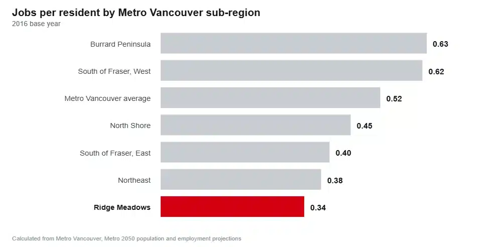
Ridge Meadows had 35,800 jobs for 105,500 people in 2016, which is 0.34 jobs per resident against a regional average of 0.52. Metro Vancouver’s growth strategy projects 55,100 jobs for 155,000 people by 2050, which nudges the ratio to 0.36 and leaves it still the lowest in the region.
TransLink’s own area transport plan puts numbers on what that means day to day: 62 per cent of residents commute out of the area, 91 per cent of those trips are made by car, and the average commute trip runs 20 kilometres, which the plan describes as one of the highest in the region.
We are not going to give you an average commute time in minutes, because Statistics Canada’s tables would not open and no municipal document quotes one. Every figure you see elsewhere is unsourced. Distance, mode and cost are all published, and they tell you the same thing more reliably.
The bridges
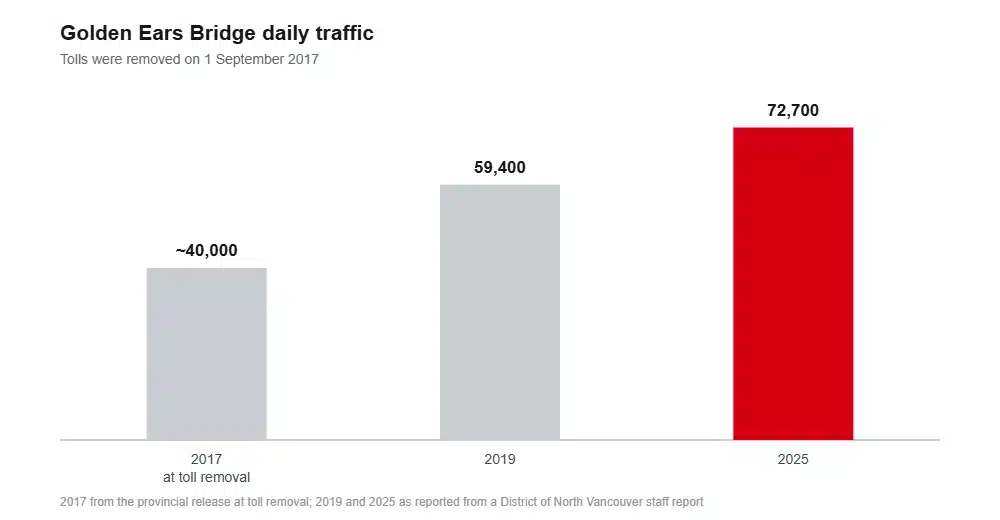
Tolls came off the Golden Ears Bridge on 1 September 2017, when it was carrying about 40,000 vehicles a day. By 2025 the reported figure was 72,700, up 20 per cent on 2019 alone. Over the same period the Pitt River Bridge, the direct route to Coquitlam and Vancouver, went from 79,000 to 80,400, which is essentially flat.
That divergence is the toll removal permanently rerouting regional traffic through Maple Ridge and Pitt Meadows. Which is also why the Haney Bypass matters: the province’s own project documentation describes queue lengths approaching half a kilometre at both ends of it and collision rates in the corridor significantly above provincial averages.
Transit, and what is actually funded
Three West Coast Express stations serve the two cities, and the train is excellent for exactly one kind of person. Five services run west in the morning and five east in the afternoon, weekdays only, nothing in the reverse direction and nothing at weekends. Port Haney to Waterfront takes 56 minutes.
The all-day service is the R3 RapidBus along Lougheed to Coquitlam Central and the Millennium Line. TransLink announced four bus rapid transit stations for the Lougheed corridor in January 2025 and Maple Ridge adopted an area plan around them in January 2026, but the project carries preliminary planning funding only. In TransLink’s wording the buses could run within three years once the projects are fully funded. There is no funded SkyTrain extension of any kind.
The jobs that do exist
The bedroom community label is fair but incomplete. E-One Moli Energy Canada, a lithium battery manufacturer, is the city’s largest private employer, alongside Fraser Health at Ridge Meadows Hospital and School District 42. The city is chasing more: it approved a 500-acre industrial area plan on 256 Street in June 2026 and says it needs another 69 to 93 hectares of industrial land by 2040.
Film is the genuinely surprising one. Maple Ridge runs its own film office, ranks fourth in British Columbia for on-location filming with 6.5 per cent of the provincial total, handles around 110 productions and 300 permits a year, and reckons nearly 2,000 residents work in the industry. All of that without a studio in the city.
Pitt Meadows has its own story. Its economic strategy notes it grew non-home-based employment more than any other municipality in the region between 2016 and 2021, largely through the Golden Ears Business Park, though more than 5,000 of its residents still worked in another community in 2021. The regional airport is owned by a not-for-profit society and reported aircraft movements rising from 101,000 in 2020 to 209,000 in 2025.
Regional unemployment across Mainland and Southwest BC was 6.8 per cent in June 2026. No municipal rate is published.
Healthcare
Ridge Meadows Hospital opened in 1958 and runs 24/7 emergency, intensive care, maternity, paediatrics, general surgery, orthopaedics including hip and knee replacement, oncology, inpatient psychiatry and full medical imaging including an MRI suite that opened in November 2020. Its foundation reports 125 acute care beds, 10 hospice beds and 148 residential care beds. An urgent and primary care centre operates in the community as well.
On family doctors, Fraser Health is the second best-attached authority in the province, with 49 people per 1,000 on the Health Connect Registry waiting list in July 2025, against 88 in Interior and 133 on Vancouver Island.
Two honest caveats. Major trauma, cardiac surgery and neurosurgery mean Royal Columbian in New Westminster, roughly 35 kilometres down the Lougheed. And despite the city growing 11.9 per cent between 2021 and 2024, we could find no announced or funded major expansion of Ridge Meadows Hospital.
Schools
School District 42 has about 17,000 students and is growing faster than it planned for. Its own residential development report, reviewed by trustees in January 2026, counted 12,000 new homes in the pipeline, mostly apartments in Maple Ridge, projected 1,954 extra students over fifteen years and concluded the district needs 80 new classrooms.
Under way now: Eric Langton Elementary is being seismically replaced and expanded at a cost of $46 million, taking it from 440 places to 680, with occupancy targeted for mid-2026. A full replacement of Pitt Meadows Secondary is also in design. Blue Mountain and Golden Ears elementaries each received prefabricated additions in 2024, worth 120 and 195 seats.
The case for, which is a strong one
Golden Ears Provincial Park covers 62,539 hectares, more than twice the land area of the city itself. It became a Class A park in 1967, it holds the 17-kilometre Alouette Lake reservoir, and BC Parks recorded 1,051,767 visits in 2022 to 2023 and 1,012,471 the following year.
Here is the part that captures living here better than any statistic. The main entrance to the province’s fourth-busiest park runs down Dewdney Trunk Road, onto 232nd Street and then onto Fern Crescent, which is an ordinary residential street in Silver Valley. BC Parks is now preparing a recreation facility plan citing rising visitation and parking congestion, and a day-use pass is required in peak summer.
Next door, UBC’s Malcolm Knapp Research Forest runs to 5,157 hectares, about four kilometres wide and thirteen long, climbing from the edge of town to a thousand metres. The public can walk in. A five-thousand-hectare university forest at the end of the suburbs is an unusual thing to have.
Add Kanaka Creek Regional Park, which took 528,000 visits in 2025 and was expanded by 3.5 hectares in August 2026, plus Pitt Lake, Widgeon Creek and 60 kilometres of dike top in Pitt Meadows that doubles as the flattest continuous cycling network in the region.
The rain
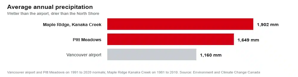
On matching 1991 to 2020 normals, Pitt Meadows averages 1,649mm of precipitation a year against 1,159.5mm at Vancouver airport. Call it 42 per cent more, or roughly an extra 490mm.
Wetter again is Maple Ridge proper. The Kanaka Creek station recorded 1,901.9mm, though on the older 1981 to 2010 period, so treat it as an indication of the gradient rather than a direct comparison. That gradient is the point: rainfall climbs sharply as you move north and east against the Coast Mountains, which means Silver Valley and Whonnock are meaningfully wetter than the Fraser flats a few kilometres south.
The rest of the honest list
Flood risk is the structural one, and it is worse in Pitt Meadows than most buyers realise. Eighty-six per cent of its residents live in a floodplain, behind 60 kilometres of dikes and six pump stations, with 177 kilometres of ditches and 736 culverts behind them. The city’s own mitigation planning, allowing for a metre of sea level rise by 2100, identifies $121 million to $135 million of upgrades against a tax base several times smaller than its neighbours’.
There are two separate flood systems in Maple Ridge. The Fraser edge is diked and pumped. The North and South Alouette rivers are not diked at all and respond to rainfall intensity, with BC Hydro able to moderate the South Alouette only within the limits of the dam. Anyone buying in Pitt Meadows, Hammond, Albion, Ruskin or along the Alouette should pull the municipal floodplain map and the flood construction level for that specific property before making an offer.
Wildfire is real but rated modestly. About 60 per cent of Maple Ridge is forested and there is a wildfire development permit area with building and landscaping requirements attached. The plan flags Silver Valley, Golden Ears, Alico, Blue Mountain, Ruskin, Albion and Whonnock for constrained emergency access. The fire chief’s own assessment in October 2025 was that the risk sits on the lower side.
Homelessness rose sharply. The March 2025 count found 183 people in Ridge Meadows against 135 in 2023, a 37 per cent increase against nine per cent regionally, concentrated in the unsheltered category. Three provincially funded supportive housing sites operate in Maple Ridge, and the Province has conceded that one of them, the 2018 temporary modular on Royal Crescent, was not built to serve as long-term supportive housing and is being replaced.
So, is it a good place to live?
Yes, clearly, if you work locally, work from home, or have a weekday downtown job that the train fits. You get more house than anywhere comparable, a genuine wilderness at the end of your street, a hospital, a growing school district and a small-city feel that most of Metro Vancouver has lost.
Think carefully if your job is in Burnaby, Richmond or Surrey and you will be driving to it five days a week. The $25,000 transportation figure is not a worst case, it is the average, and the region’s own plan does not expect the job balance here to improve much in the next twenty-five years.
Frequently asked questions
Is Maple Ridge a nice place to live?
For outdoor access, space and a small-city feel, few places in Metro Vancouver compete. The honest counterweight is that it has the region’s lowest ratio of jobs to residents, so most households are commuting out of it.
How long is the commute from Maple Ridge to Vancouver?
Nobody publishes a verifiable average, and we are not going to invent one. What is published: the average commute trip from here runs 20 kilometres, 91 per cent of out-commuting is by car, and the West Coast Express takes 56 minutes from Port Haney when it is running.
Does it rain a lot in Maple Ridge?
Yes. The Pitt Meadows station averages 1,649mm a year against 1,159.5mm at Vancouver airport on the same measurement period, and the Maple Ridge stations run higher again. The further north and east you live, the wetter it gets.
Is there a hospital in Maple Ridge?
Yes. The hospital sits on Laity Street, with a 24-hour emergency department, intensive care, maternity, surgery and an MRI. Major trauma and cardiac or neurosurgery go to Royal Columbian in New Westminster.
Is SkyTrain coming to Maple Ridge?
No funded project exists. Bus rapid transit along Lougheed has preliminary planning funding, and TransLink says it could be running within three years once fully funded. Four station areas have already been planned around it.
How we put this together
Figures come from Metro Vancouver, TransLink, the Province of British Columbia, BC Parks, Fraser Health, BC Health Data, School District 42, the two cities and Environment and Climate Change Canada, linked where they appear.
Four gaps we would rather name. No verifiable average commute time exists for either city, so we have used distance, mode and spending instead. The bridge traffic figures for 2019 and 2025 come from a staff report quoted in regional coverage rather than a primary document we could open, and are labelled as reported. The climate normals were read from tables citing Environment Canada rather than from its own search tool, which would not run. And the hospital bed counts come from the hospital’s foundation, because Fraser Health does not publish them.
Sources
- Metro Vancouver, housing and transportation cost burden study update, August 2025
- Metro Vancouver, Metro 2050 targets and projections
- TransLink, Maple Ridge and Pitt Meadows area transport plan
- TransLink, bus rapid transit programme
- Province of British Columbia, bridge toll removal, 2017
- Province of British Columbia, Haney Bypass intersection improvements
- City of Maple Ridge, film policy and film industry figures
- City of Maple Ridge, 256 Street industrial area plan
- City of Pitt Meadows economic development strategic plan
- Fraser Health, Ridge Meadows Hospital
- BC Health Data, primary care attachment
- School District 42, strategic facilities plan
- BC Parks visitor attendance report, 2018 to 2024
- BC Parks, Golden Ears Provincial Park
- UBC Malcolm Knapp Research Forest
- City of Pitt Meadows, dikes
- City of Maple Ridge, flood readiness
- City of Maple Ridge community wildfire protection plan update
- 2025 Point-in-Time Homeless Count for Greater Vancouver
- WorkBC, Mainland and Southwest region profile
The northeast sub-region next door has the same shape of problem with SkyTrain attached, and we have made the case both ways for Coquitlam.
Still weighing it up? Our area guide covers what each part of the city is actually like, the cost breakdown prices out tax, rent and the commute, and the crime numbers separate Maple Ridge from Pitt Meadows. When the decision is made, tell us where you are moving from.
