

Two things before the tour. Maple Ridge rewrote nearly its whole area-plan framework between October 2025 and January 2026 to meet a provincial deadline, so anything written about its neighbourhoods before late 2025 is out of date. And Pitt Meadows is a separate city, so Osprey Village and South Bonson are not Maple Ridge addresses no matter what a listing says.
The other thing worth saying at the top: no primary source publishes house prices by neighbourhood here. Greater Vancouver Realtors reports benchmarks for Maple Ridge and Pitt Meadows as whole municipalities and goes no finer. Every “average price in Silver Valley” you will find online comes from an unpublished brokerage extract. What follows is character, planning, transit and trade-offs, because those can be sourced.
The official geography, and what is just a name
Maple Ridge has six formal area plans: Town Centre, Albion, Hammond, Silver Valley, the Lougheed Transit Corridor and the North 256 Street industrial lands. Below those sit endorsed concept plans for Albion Flats and Yennadon. A separate public list of ten neighbourhoods adds Port Haney, Ruskin, Thornhill, Websters Corners and Whonnock.
Two names people use constantly are not on any of those lists. Cottonwood is a real place with a real bus route and a real elementary school, but it is a colloquial and MLS name rather than a planning designation. Academy Park does not appear in any city planning source at all.
Town Centre
The downtown, and the part of Maple Ridge changing fastest. It held about 12,430 residents in 6,520 households in 2021, up from just over 8,000 when the area plan started in 2008. The November 2025 update pulled the boundary out to include River Bend, cut the land use designations from eleven to seven and created a Town Centre Core designation for higher density.
Memorial Peace Park sits in the middle of it, with the bandstand, the Cenotaph and the Haney Farmers Market. The Leisure Centre is across the way, and the city’s own 2026 reporting describes it as at or near capacity.
Best for anyone who wants to walk to things and use the train. The trade-off: two provincially designated transit-oriented areas sit here, at Haney Place and Port Haney Station, where the minimum permitted height within 200 metres is twelve storeys. The neighbourhood you buy into is not the one you will live in a decade from now.
Silver Valley
The hillside north of the Alouette River, and the most deliberately designed part of the city. The adopted plan divides it into four named hamlets: Blaney, Forest, River Village and Horse Hamlet, each built on a 400-metre walking radius from a central square. Those are official geography, not marketing.
Density is capped low. River Village mixed-use at four storeys is the tallest thing permitted anywhere in Silver Valley; hamlet commercial and medium-density residential top out at three. The plan sets an objective of holding impervious surface to 15 per cent, and it maps salmon spawning habitat and wildlife corridors through the area.
Best for families who want new build, big trees and a trailhead at the end of the street. The trade-off: effectively no transit, steep-slope building rules covered below, and the fact that every car heading for Golden Ears Provincial Park turns off 232nd onto Fern Crescent, which is River Village’s main street. On a hot Saturday that is the whole Lower Mainland driving past your house.
Albion and Kanaka
Where most of the family growth has landed. The area plan update adopted on 28 October 2025 added walking and cycling connections, backed local commercial nodes and introduced buffers where new housing meets farmland.
The proof of the growth is in the school district’s capital list: Golden Ears Elementary in Albion got an eight-classroom addition worth 195 seats, announced in September 2024.
Albion Flats is a separate story and a long one. The flats sit inside the Agricultural Land Reserve. A city charrette produced a plan for retail, offices and recreation; in December 2011 the Agricultural Land Commission turned down the part covering the western third of the area. Fifteen years later the constraint is still live: the city’s plan to expand the Albion Fairgrounds arena to five ice sheets is currently seeking commission reconsideration for the fifth sheet.
Best for families buying newer detached and townhouse stock near a school. The trade-off: you are living against the edge of the ALR, which is why even an ice rink needs provincial permission.
Hammond
Established as a township in 1883 and, by the city’s own description, rich with character and a popular filming location. Hammond is also the sharpest tension in Maple Ridge planning right now.
A heritage character study identified the highest concentration of heritage features in Upper Hammond, around the old station, mill and commercial centre. Council received the outcomes report in July 2021 and noted that further review was needed before any regulation. None has been adopted. There is no heritage conservation area in Hammond.
Meanwhile the November 2025 area plan update directs growth around Maple Meadows Station with eight to twelve storey mixed-use near transit. So the character is documented but unprotected, and the same blocks are now a designated transit-oriented area.
On the plus side, a new aquatics and recreation centre at Hammond Community Park is planned to replace the ageing outdoor pool and hall, with design running through 2026 and construction possibly starting in 2027.
Best for buyers who want old character housing near a train station at prices below Silver Valley. The trade-off: the character has no legal protection and the plan invites height.
Port Haney
Historically the steamboat landing and the CPR stop, now part of the Town Centre area plan and home to Port Haney Station, which opened in 1995 and is served by seven bus routes across three bays. The station area is also transit-oriented, with a twelve-storey minimum within 200 metres, and a multi-use pathway project is underway.
Best for the weekday downtown commuter who wants to walk to the train.
Cottonwood and Yennadon
Cottonwood runs roughly east of the Town Centre between 232nd and 240th. It has its own bus route and Blue Mountain Elementary, which picked up a five-classroom, 120-seat addition in September 2024, so it is absorbing families too. Just do not expect to find it in a planning document.
Yennadon has an endorsed concept plan from December 2020 that never became an area plan. Yennadon is described by the city as an active agricultural production area with a major recreation centre, and Yennadon Elementary runs the district’s Cyberschool programme.
Websters Corners, Whonnock and Ruskin
The rural east, none of which has an area plan. Websters Corners sits towards the Mission boundary with trail networks and active film production. Whonnock is described by the city as a rural residential area where many people keep horses and small tree and fruit farms, on the traditional territories of the Katzie and Kwantlen First Nations; it has a lake with a beach and a community hall, a post office from 1932 and a general store from 1937. Ruskin still has shake and sawmills running along the Stave River.
One bus route, the 749, reaches this end of the city.
Best for acreage buyers and horse people. The trade-off: a long drive to everything, and rural servicing realities.
Thornhill
Worth understanding before you get excited about a listing. Thornhill is an urban reserve, not a serviced neighbourhood. The city describes it as a new community that requires an area plan before urban development can happen, and calls that plan a long-term priority.
Practically, that means much of it has no municipal water. Homes outside the urban reserve boundary draw on private wells into the Grant Hill Aquifer, which the province classifies as highly vulnerable. A residents’ group has been monitoring wells quarterly since 2005.
Best for people who genuinely want forest and a mountain bike network out the back and understand what they are buying. The trade-off: it is the least resolved geography in the city.
Pitt Meadows
A separate city with its own council, its own tax notice and its own constraints. About 95 per cent of it sits inside the Fraser and Pitt river floodplains and roughly 80 per cent is in the Agricultural Land Reserve. Sixty kilometres of dikes protect it.
Osprey Village, on the Fraser in the south of the city, was farmland and then a mill site. South Bonson sits next to it, around the community centre on Barnston View Road that also houses the Pitt Meadows Art Gallery. Both are genuinely quiet, to the point that the city’s filming policy prohibits shooting in Osprey Village and restricts it in South Bonson.
The town centre anchors are Pitt Meadows Station on Harris Road, the R3 RapidBus stop, and a full replacement of Pitt Meadows Secondary currently in design.
Best for people who want small-town scale, flat cycling and river frontage. The trade-off: the city asked the Province to reduce its housing target on the grounds that it physically cannot build, and was refused. Six months into that target period it had delivered six net new homes.
Where the growth is actually going
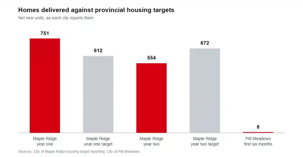
A provincial order requires Maple Ridge to deliver 3,954 net new homes by June 2029. It beat its first-year target with 751 homes against 612, then missed the second with 554 against 672, leaving it at 99.1 per cent cumulatively. Its own report puts the shortfall down to market conditions.
Its neighbour is under a 727-unit order and delivered six net new units in its first six months.
Both cities have designated transit-oriented areas around the West Coast Express stations, where provincial rules set minimum heights rather than maximums. In Maple Ridge those are Port Haney, Maple Meadows and Haney Place, at twelve storeys within 200 metres and eight storeys from 200 to 400. If you want a neighbourhood that will look the same in fifteen years, stay away from a station.
Transit, honestly
Three West Coast Express stations serve the two cities: Pitt Meadows on Harris Road, Maple Meadows on Dunn Avenue just inside the Maple Ridge boundary, and Port Haney. All three are Zone 4, and the train runs five times west in the morning and five times east in the afternoon, weekdays only, with nothing in the reverse direction and nothing at weekends.
The all-day, all-week service is the R3 RapidBus, running 17.2 kilometres from Haney Place through Pitt Meadows to Coquitlam Central and the Millennium Line, with eight stops. TransLink announced four bus rapid transit stations for the Lougheed corridor in January 2025, at 203rd, 207th, Laity and 216th, and Maple Ridge adopted an area plan around them a year later. That project has planning money rather than construction money.
Everywhere else is a local bus at best. Silver Valley, Thornhill, Whonnock and Ruskin are car-dependent in practice, not in theory.
Schools
School District 42 covers both cities. French Immersion runs early at Eric Langton, Laity View and Pitt Meadows Elementary, late at Golden Ears, and continues at Maple Ridge Secondary and Pitt Meadows Secondary. The district has been running immersion since 1980.
The capital plan tells you where the families are going. Eric Langton in the Town Centre is being seismically replaced and expanded, Pitt Meadows Secondary is being fully replaced, and Blue Mountain in Cottonwood and Golden Ears in Albion both received prefabricated additions in 2024. SD42 has also bought land in Blaney Hamlet for a possible future Silver Valley school.
The two hazards that decide which lots are buildable
Slope first. Building on a slope over ten per cent needs a letter of assurance; on or near a slope over twenty per cent it needs a letter and a geotechnical report; and the zoning bylaw prohibits development on slopes exceeding 25 per cent outright. That applies squarely to Silver Valley and Thornhill, and it can mean real engineering costs on a pretty lot.
Water second. In Pitt Meadows the 2018 flood hazard assessment found dikes built to 1969 design elevations that the Province now considers too low, with inadequate seepage control and poor expected seismic performance. A one-in-500-year Fraser freshet was modelled at nine kilometres of dike overtopped, $489.3 million in damages and about 15,195 people affected. Add a metre of sea level rise by 2100 and the model puts 50 kilometres of dike overtopped and $725.8 million in damage.
Over in Maple Ridge the flood exposure runs along the Fraser through Hammond, Port Haney and the Albion and Ruskin waterfront, and along the Alouette rivers. The hillsides are the slope risk; the flats are the flood risk. About 60 per cent of the city is forested, and it carries a wildfire development permit area on the north side where housing meets the research forest and the park.
Frequently asked questions
What is the nicest area of Maple Ridge?
Depends what you are optimising for. New build and trailheads point to Silver Valley, walkability and the train to the Town Centre, family stock near a school to Albion, acreage to Whonnock or Websters Corners, and old character housing to Hammond.
Is Silver Valley a good place to live?
For families who want space and forest, very much so. It is capped at low density by its own area plan, which protects the feel of it, and it has almost no transit. Golden Ears Park traffic runs through it every summer weekend.
Is Osprey Village in Maple Ridge?
No. Osprey Village and South Bonson are in Pitt Meadows, a separate city with its own council and tax rate. Maple Meadows Station, despite the name, is just inside Maple Ridge.
Which Maple Ridge neighbourhood has the best transit?
Town Centre and Port Haney, on the strength of the Haney Place exchange, the R3 RapidBus and the West Coast Express. Close behind is Hammond, on Maple Meadows Station.
Where is the cheapest place to buy in Maple Ridge?
Nobody publishes prices by neighbourhood, so any specific answer is a guess. What is published is the municipal picture: an apartment benchmark of $504,300, a townhouse benchmark of $704,100 and a detached benchmark of $1,177,800 in August 2026, with apartments concentrated in the Town Centre.
How we put this together
Area names and planning status come from the City of Maple Ridge’s own official community plan, area plans and concept plan pages, and from the City of Pitt Meadows. Housing target figures come from both cities’ provincial reporting, prices from Greater Vancouver Realtors, schools from School District 42, transit from TransLink, and flood and slope information from the cities’ own engineering documents.
Three things we would not do. No neighbourhood-level prices appear here, because no primary source publishes them. We have not presented Cottonwood or Academy Park as official designations, because the city does not. And we have not repeated the widely quoted detail of which streets the 2011 Albion Flats decision covered, because the only source we found for it is a blog.
Sources
- City of Maple Ridge, area and neighbourhood plans
- City of Maple Ridge, our neighbourhoods
- City of Maple Ridge, Silver Valley Area Plan
- City of Maple Ridge, transit-oriented areas
- City of Maple Ridge, housing target order reporting
- City of Maple Ridge, Hammond heritage
- City of Maple Ridge, sloping sites geotechnical requirements
- City of Maple Ridge, flood readiness
- City of Pitt Meadows flood hazard risk assessment, 2018
- City of Pitt Meadows, dikes
- City of Pitt Meadows, provincial housing targets
- School District 42, strategic facilities plan
- School District 42, French Immersion
- TransLink, West Coast Express
- Greater Vancouver Realtors MLS Home Price Index statistics
Heading west along the same highway, our guide to the Tri-Cities does the same job for Coquitlam, Port Coquitlam and Port Moody.
Narrowed it down? Our cost breakdown prices out tax, utilities and the commute for both cities, the crime numbers separate Maple Ridge from Pitt Meadows, and the wider case for and against weighs the whole thing up. When you have picked a street, tell us where you are moving from.
