

Last updated: August 2026
Abbotsford is big. It runs from the Fraser River down to the US border, and from Bradner farmland in the west to Sumas Mountain in the east. Calling any of it “Abbotsford” is a bit like calling the whole Fraser Valley “out east.”
The City publishes 20 community-area profiles, and they describe genuinely different places: a 1970s Clearbrook rancher and a hillside house in Auguston are not the same product in the same market.
Here’s what each area is actually like. No rankings, because “best” depends entirely on whether you want a school catchment, a shorter commute or a bit of land.
Quick orientation
Three things explain almost everything about where you should look:
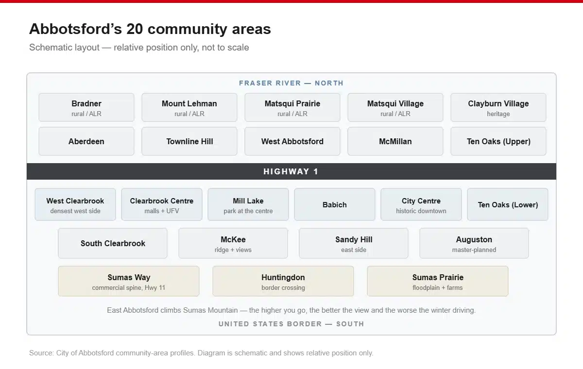
- Highway 1 splits the city east–west. North of it is older Abbotsford plus the historic districts and farmland. South of it is where most of the residential growth happened.
- Clearbrook is west, City Centre is east, and the two downtowns are a genuinely confusing thing about Abbotsford until someone tells you.
- Elevation matters here. East Abbotsford climbs Sumas Mountain, and the higher you go the better the view and the worse the winter driving.
West Clearbrook
The dense, established west side. Mostly 1970s and 80s single-family homes on generous lots, with a steady supply of townhouse and apartment stock along the arterials, one of the more realistic parts of Abbotsford for a first apartment or a rental.
Clearbrook is also the centre of Abbotsford’s Punjabi community, which shapes the food, the shops and the temples in a way that makes it one of the more interesting parts of the city to actually live in. Punjabi accounts for 65.8% of non-official-language speech in Abbotsford, and this is where you feel that most.
Suits: first-time buyers, renters, anyone who wants to be able to walk to groceries.
South Clearbrook
Quieter and more residential than West Clearbrook, running down toward the flats. Predominantly single-family, older stock, larger lots. South Poplar Traditional Elementary is nearby and rated 6.9/10 by the Fraser Institute in its 2025 elementary report card.
Suits: families who want space without the price of the east side.
Clearbrook Centre
The commercial heart of west Abbotsford, with malls, services, medical offices, and the Clearbrook Centre campus of the University of the Fraser Valley. Housing is mostly multi-family and apartment.
Suits: students, downsizers, anyone who wants to not drive much.
West Abbotsford
The growth area. A lot of Abbotsford’s newer subdivision and townhouse construction has landed here, which means newer homes, wider roads, fewer mature trees and more of everything being fifteen minutes away by car rather than five.
Suits: buyers who want new build and don’t mind a car-dependent street.
Abbotsford City Centre (Historic Downtown)
Essex, Montrose, and the stretch of old storefronts that Abbotsford has spent the last decade trying to bring back. There are good restaurants and a genuine main-street feel that the rest of the city doesn’t have. There’s also the most visible homelessness in Abbotsford, and that’s the honest trade.
Housing is a mix of older character homes on the surrounding streets and newer apartment infill.
Suits: people who want walkability and a downtown, and who’d rather live somewhere with a bit of grit than somewhere with none.
McMillan
North-central, established, family-oriented. McMillan Elementary rated 7.2/10 in the Fraser Institute’s 2025 report card, one of the higher-rated public elementaries in the city. Mostly single-family on regular lots, close to the Abbotsford Recreation Centre and Rotary Stadium.
Suits: families who want a settled neighbourhood with a school reputation attached.
Mill Lake
Central Abbotsford, wrapped around Mill Lake Park, which is the closest thing the city has to a Stanley Park: a proper lake, a proper loop trail, and a lot of people walking it every evening. Housing runs from older single-family to a solid amount of apartment and townhouse stock overlooking the park.
Suits: downsizers, dog owners, anyone who wants their daily walk to be the reason they live there.
Aberdeen
West of the city proper, out toward the Mount Lehman side. Larger lots, semi-rural in feel, quiet. The City publishes Aberdeen as its own community area, which tells you it functions as a distinct place rather than a subdivision.
Suits: people who want a bit of land and don’t need to walk to anything.
Auguston
Purpose-built on the slope of Sumas Mountain in east Abbotsford, and it looks and feels different from the rest of the city, with planned streets, a village green, a deliberate community layout. Auguston Traditional Elementary rated 6.8/10 in 2025.
It’s one of the more expensive parts of Abbotsford and it knows it.
Suits: families who want the master-planned, everyone-knows-everyone version of suburbia and will pay for it.
Sandy Hill
East Abbotsford, next door to Auguston in feel if not in price. Family housing, hillside streets, good access to Highway 1 at Whatcom Road. Sandy Hill Elementary rated 6.8/10 in 2025.
Suits: families wanting east-side schools without the Auguston premium.
Clayburn Village
A genuine 1900s company town built for the Clayburn brick works, now a heritage conservation area: brick cottages, a village store, and a scale that nothing else in Abbotsford matches. Very small, tightly held, rarely available.
Suits: people who want a heritage house and are prepared to wait for one.
Townline Hill
Elevated ground between Clearbrook and the west side, with a lot of newer single-family and townhouse development. Views west across the valley from the upper streets.
Suits: buyers who want newer stock and a view without going east.
Babich
Small, central, residential. Older single-family stock, close to Mill Lake and the recreation centre. One of the quieter central pockets.
Suits: buyers looking for a central location at less than a central-Abbotsford price.
McKee
South-central, running up the McKee ridge. Established single-family homes, some of them with the best south-facing views in the city looking over the Sumas flats toward Mount Baker.
Suits: buyers who want a view and a mature neighbourhood.
Ten Oaks (Upper and Lower)
Two adjacent community areas on the eastern side. Predominantly single-family, established, close to the Highway 1 corridor and the east-side shopping around Sumas Way.
Suits: commuters who want quick highway access.
Sumas Way
Not somewhere most people think of as a neighbourhood, but it’s the commercial spine running south toward the Huntingdon border crossing. Residential pockets sit off it. Convenient, busy, and loud in the places closest to the road.
Suits: people prioritising convenience and price over quiet.
Huntingdon
The border community at the very south end of Sumas Way, at the Sumas/Huntingdon crossing. Small, mixed residential and industrial, and defined by the border traffic.
Suits: cross-border commuters, and almost nobody else.
Matsqui Village and Matsqui Prairie
Matsqui Village is a small historic settlement on the north side toward the Fraser; Matsqui Prairie is the farmland around it. Genuinely rural, genuinely quiet, dike trails along the river.
Suits: people who want farmland and a fifteen-minute drive to everything.
Bradner and Mount Lehman
Abbotsford’s rural west. Bradner is daffodil country (the Bradner Flower Show has been running for decades) and Mount Lehman is acreage and small farms. Mt Lehman Elementary rated 6.6/10 in 2025.
This is Agricultural Land Reserve territory, so it stays this way.
Suits: acreage buyers, horse people, anyone who wants land inside city limits.
Sumas Prairie
The eastern floodplain, and the most agriculturally productive land in the city: dairy, poultry, berries. It’s also the area that flooded in November 2021.
Since then roughly $220 million has gone into recovery, preparedness and mitigation for Abbotsford and Sumas Prairie, including $76.6 million for Barrowtown pump station upgrades and $62 million for water treatment infrastructure. A Sumas River Watershed flood mitigation planning initiative is underway with Canada and the US.
But there was further flooding in December 2025. The risk has been reduced, not removed. If you’re looking at Sumas Prairie, read the flood mapping and talk to an insurance broker before you fall in love with a property.
Suits: farmers and people who have done the flood homework properly.
The short version, by what you’re actually optimising for
| If you want… | Look at |
|---|---|
| Walkable, cheapest entry | West Clearbrook, Clearbrook Centre |
| A real downtown | Abbotsford City Centre |
| School reputation | McMillan, Auguston, Sandy Hill, South Poplar |
| Newer build | West Abbotsford, Townline Hill |
| A view | McKee, Townline Hill, upper Auguston |
| Land | Bradner, Mount Lehman, Aberdeen, Matsqui Prairie |
| Heritage | Clayburn Village |
| Park at your door | Mill Lake |
| Quick highway access | Ten Oaks, Sandy Hill, Sumas Way |
A note on the school ratings
The ratings above come from the Fraser Institute’s Report Card on British Columbia’s Elementary Schools 2025, published November 2025 using 2023/24 data. It scores schools out of 10 on eight indicators derived from the provincial Foundation Skills Assessment.
It’s an advocacy organisation’s ranking, not a government one, and it measures a narrow slice of what a school does. The highest-rated schools in Abbotsford were Mennonite Educational Institute at 7.7 and Abbotsford Christian at 7.3, both independent, with Prince Charles Elementary matching at 7.3 among public schools.
Also worth knowing: the Fraser Institute has not published a BC secondary school report card since 2020, so anyone showing you current high-school rankings for Abbotsford is showing you something else.
The Abbotsford School District runs 47 public schools within a catchment that also holds 8 independents, serves 21,160 students, and reports an 89% five-year completion rate. Families speak close to 100 languages across the district.
Frequently asked questions
What are the nicest neighbourhoods in Abbotsford?
East Abbotsford, Auguston and Sandy Hill in particular, carries the highest prices and the newest housing stock. Clayburn Village is the most distinctive. But “nicest” and “best value” point in opposite directions here; West Clearbrook and Mill Lake do far better on the second measure.
Where is the Abbotsford neighbourhood map?
The City of Abbotsford publishes 20 community-area profiles at abbotsford.ca under Business Development → Statistics, with boundaries and demographic data for each. They’re built on 2021 census data.
What’s the difference between Clearbrook and Abbotsford?
Clearbrook is a neighbourhood of Abbotsford, not a separate place. It was a distinct community historically and still functions as west Abbotsford’s own centre, with its own shopping district, which is why Abbotsford confusingly has two downtowns.
Which Abbotsford neighbourhoods are safest?
Nobody publishes crime data by Abbotsford neighbourhood: not the police department, not Statistics Canada, not the City. The Abbotsford Police crime map at abbypd.ca/crime-mapping shows actual reported incidents and is the only reliable way to look at a specific area.
Is Sumas Prairie safe to buy in after the flood?
About $220 million has gone into flood recovery and mitigation since 2021, including major pump station upgrades. But there was further flooding in December 2025. Get the current flood mapping and an insurance quote before committing.
Once you’ve picked the neighbourhood, we’ll handle the boxes — here’s how we move people around Abbotsford.
