

Start with something no other guide will tell you. The City of New Westminster publishes at least three different official neighbourhood lists, and they do not agree with each other.
The official community plan has a residential neighbourhoods map with ten areas. The same plan has a statistical planning boundaries map with fifteen. The city recognises twelve residents’ associations, on a different set of lines again. So when a listing says a house is in Kelvin or Moody Park or Fraserview, it may be quoting one of those maps, or a community group’s boundary, or nothing at all.
And the other thing worth saying at the top: no primary source publishes house prices by neighbourhood here. Greater Vancouver Realtors reports New Westminster as one whole municipality and goes no finer. Every “average price in Queen’s Park” you will find online is an unpublished brokerage extract. What follows is character, planning status, transit, schools and trade-offs, because those can be sourced.
The three lists, and what is only a name
The official community plan’s residential neighbourhoods map names ten: Queensborough, Connaught Heights, West End, Moody Park, Brow of the Hill, Glenbrooke North, Queen’s Park, Massey Victory Heights, McBride Sapperton and Downtown including Quayside.
The statistical planning boundaries map, revised in September 2017, names fifteen and swaps several around. It splits out Kelvin, Uptown, Glenbrooke South, Sapperton and Victory Heights, adds the industrial areas of North Arm North, North Arm South and Brunette Creek, and drops Moody Park entirely.
The residents’ associations are a third geography again, and the city is explicit that they are independent volunteer community groups rather than planning areas. That list adds Quayside and Victoria Hill Ginger Drive.
Seven names appear on all three: Queensborough, Connaught Heights, West End, Brow of the Hill, Glenbrooke North, Queen’s Park and Downtown. Those are the safest ground. Uptown, Kelvin and Glenbrooke South exist for statistics and planning but not on the residential map. Moody Park works the other way around.
One name to be careful with. Fraserview does not appear on any city map, plan, development permit area schedule or residents’ association list. It is an MLS label and nothing more.
Downtown and Quayside
The most planned part of the city and the one absorbing the most growth. Downtown has its own adopted area plan as a schedule to the official community plan, its own development permit area, and status as a Regional City Centre in Metro Vancouver’s growth strategy. Its own plan describes it as a high-density historic heart that provides services to the whole city.
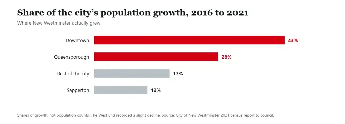
Both New Westminster and Columbia stations sit here, both designated transit-oriented areas by the province. Downtown took 43 per cent of the city’s entire population growth between 2016 and 2021, more than any other area by a distance.
Quayside is the waterfront piece, folded into Downtown on the residential map but recognised with its own community board and its own heritage context statement. Its heritage statement describes a distinctive built pattern of low-rise structures at the front and high-rises behind. Pacific Coast Terminals operated on this ground from 1928 to 1981; the first residential tower went up in 1987.
Best for people who want to walk to a train, a market and a river. The trade-off: the mainland waterfront sits in the floodplain and is not diked, and Front Street faces up to six months of closure while the old Pattullo Bridge comes down.
Queensborough
The most distinctive geography in the city, and the one people most often misunderstand. Queensborough is not on the same landmass as the rest of New Westminster. It occupies the eastern tip of Lulu Island, the same island as Richmond, separated from the mainland city by the Fraser River and reached by the Queensborough Bridge.
Queensborough has its own adopted community plan, originally adopted by bylaw in February 2014 and revised in 2017, covering about 303 hectares. This is the second fastest-growing part of the city, taking 28 per cent of population growth between 2016 and 2021. The plan tracks a genuine transformation: residential uses went from 47 per cent of floorspace in 1991 to 65 per cent by 2011, while industrial fell from 44 to 18.
Three things make buying here different from buying anywhere else in New Westminster.
First, it has no SkyTrain. Every other named residential area in the city is within reach of one of the five stations. Queensborough connects by bus, principally the 104 to 22nd Street Station.
Second, all of it is floodplain. The whole community sits behind roughly seven kilometres of dike that it shares with Richmond, so its flood protection partly depends on another municipality. Municipal analysis attributes about 75 per cent of its estimated annual flood damages to Queensborough. A flood hazard development permit applies to nearly all construction, with flood construction levels of 3.53 or 4.20 metres depending on which side of Derwent Way you are.
Third, the ground itself is difficult. Queensborough has, in the city’s own words, unusual soil conditions that make it hard to build on. Applications typically require preload and settlement details, pile foundations rather than standard ones, geotechnical reports and soil gas assessments including methane. Most new development, single detached houses included, needs a development permit as well as a building permit.
One more thing worth knowing. When New Westminster liberalised its infill housing rules in June 2026, Queensborough was deliberately left out, because the city wants more research on whether the infrastructure can carry the density. The province granted a compliance extension to 4 May 2029.
Best for buyers who want newer detached and townhouse stock, river frontage and Richmond on the doorstep. The trade-off: no train, real flood exposure, expensive foundations, and children travel to the mainland for secondary school.
Sapperton and McBride
Called Sapperton on the statistical map and McBride Sapperton on the residential one, which tells you something about how the city thinks about it. Both names are city usage.
It began as a separate community outside the city limits, a Royal Engineers camp in the 1860s, and it kept that character. The city’s own heritage context statement describes small-town suburban development with working-class roots and a close-knit historic feel, valued for its singularity. Royal Columbian Hospital dates from 1862 and St Mary’s Church from 1865; the neighbourhood was absorbed into New Westminster in 1889. Early-1900s heritage houses concentrate around Keary and East Columbia, with post-war apartments along Hospital and Keary streets.
Two SkyTrain stations serve it, Sapperton and Braid, both designated transit-oriented areas and both due for expanded frequent transit development area boundaries. Sapperton took 12 per cent of the city’s 2016 to 2021 growth, third behind Downtown and Queensborough.
There is no adopted Sapperton area plan. The neighbourhood is governed through development permit areas instead, including two major redevelopment sites, Sapperton Green and the Brewery District.
Best for anyone working at the hospital, and buyers who want older character housing beside two stations. The trade-off: hospital traffic, the unresolved Brunette interchange question, and two rail crossings still waiting on whistle cessation into 2026 and 2027.
Uptown
One of the densest parts of New Westminster and the notable one without a station of its own. It sits on the statistical map and as a development permit area, but not on the residential neighbourhoods map and not as a residents’ association.
A heritage statement puts its character down to its uphill location, its mixed heritage and its mid-century commercial evolution. Housing runs from 1890s estates through pre-war cottages to a lot of 1960s and 1970s high-rises, which is why the rental share here is so high. The library opened in 1958, City Hall is here, and so are the Massey Theatre and the Sixth Street and Sixth Avenue commercial corridors.
Council is responding to the missing station with a new frequent transit development area for Uptown, supported by council in May 2026 and expected to be adopted in the autumn.
Best for renters and buyers who want an apartment within walking distance of shops, the library and a theatre. The trade-off: you are on a bus to the train, and the designation now attached to the area is an invitation to build more.
Queen’s Park
The oldest and grandest residential area, laid out by the Royal Engineers in 1859 as part of a capital city and built out with Victorian and Edwardian houses on large lots from the 1880s. It declined mid-century as houses were carved into suites and was revived from the 1970s onward through heritage conservation.
That conservation is now a legal regime and anyone buying here needs to understand it. The Queen’s Park Heritage Conservation Area was adopted in June 2017 by bylaw, covers roughly 118 hectares bounded by Royal, Sixth Avenue, Sixth Street, First, Vancouver and Granville, and is a schedule to the official community plan. It is the only heritage conservation area in the city and it has not been repealed. Three amendments have been made to it, in 2018 twice and 2019.
Houses built in 1940 or earlier fall into the protected category, along with designated houses and those on the heritage register. A heritage alteration permit is needed to change the front or sides, to add floor space, to change windows or doors, to alter a roof form visible from the street, or to subdivide. Houses from 1941 onward need a permit to build new, to add a detached accessory dwelling, or to subdivide.
Demolition of a protected house is assessed against a scored checklist, and the city’s own guide says a score of 10 out of 18 or less means demolition will be considered reasonable.
The route to that regime is worth knowing too. Between June 2016 and June 2017 the city ran a temporary heritage control period that let it reject demolition and renovation applications for any house built before 1967, while the policy was worked out. That is the fact at the centre of a dispute the city itself does not summarise anywhere, so we are not going to characterise the argument for you.
Best for people who want a genuinely historic house and are happy to be a custodian of it. The trade-off: a permit regime on the things most owners want to change, and a scored test standing between a protected house and a bulldozer.
West End, Moody Park and the Glenbrookes
The West End is described by the city as the modest working-class counterpart to Queen’s Park, with river views and a strong lane network. It was farmland until the 1890s and filled in through an interwar bungalow boom. It is also the only area the city recorded losing population between 2016 and 2021, and it sits near 22nd Street Station.
Next along, Moody Park is a plateau neighbourhood around a 25-acre park the Royal Engineers set aside in 1889, with Craftsman and Arts and Crafts houses built mostly before 1940 on consistent 50-foot lots. The neighbourhood is on the residential map and has a residents’ association, but it is not a separate area on the statistical map.
Glenbrooke North runs over variable ground including the filled Glenbrooke ravine, with housing spanning the Edwardian boom to the post-war bungalow boom. Glenbrook Middle School here runs late French immersion from grade six.
Glenbrooke South exists only on the statistical map. The one demographic profile the city ever published for it is from the 2006 census, which showed it as unusually owner-occupied and unusually settled. Two decades old, so treat it as history rather than description.
Best for buyers who want a house rather than an apartment, on the hill and out of the floodplain. The trade-off: a walk or a bus to the stations, and infill rules that now permit four to six units on most of these lots.
Connaught Heights and the 22nd Street question
The newest annexed part of the city, surveyed in 1859 but under provincial jurisdiction until 1965, built out from the 1930s as small bungalows on gravel streets and later as larger view homes. Municipal descriptions lean on its semi-rural feel and its relative isolation.
What matters more right now is what the city plans to do with it. Council endorsed a vision for the 22nd Street Station area in December 2024 and approved an implementation work plan in August 2025 that runs to mid-2027. The stated aim is to transform the station area from a predominantly single-detached community into a high-density mixed-use transit village.
Until that work finishes, the city says the area is under active review and treats redevelopment applications as premature. So if you are buying in Connaught Heights or the western West End, you are buying into several years of planning uncertainty with a large change signalled at the end of it.
The names that are not neighbourhoods, but matter
Victoria Hill and Ginger Drive is a recognised residents’ association and a development permit area, on the redeveloped former BC Penitentiary lands. Sapperton Green and the Brewery District are development permit areas within Sapperton and two of the largest redevelopment sites in the city. Port Royal is a residential sub-area within Queensborough. Kelvin is a statistical area and an elementary school and not much else as a lived identity. Brow of the Hill sits on all three city lists, and yet the city publishes almost nothing describing it, so we are not going to invent a character for it.
Where the growth is actually going
New Westminster is under a provincial order to deliver 4,432 net new homes between August 2024 and July 2029. It cleared its first-year target of 656 with 1,175 completions, of which 59 per cent were ownership and 41 per cent rental, including 552 two-bedroom and 146 three- and four-bedroom units.
Five SkyTrain stations are designated provincial transit-oriented areas: 22nd Street, New Westminster, Columbia, Sapperton and Braid. The provincial framework sets three concentric bands out to 800 metres from each platform, with the densities a city must allow rising as you get closer. The city does not publish a tier by station, so nobody can honestly tell you that Sapperton is a tier two station. What the city does say, in plain terms, is that a designation does not mean a site is pre-zoned, and rezoning applications are still required.
Away from the stations, the June 2026 infill housing program pre-zoned about 3,000 mainland properties for four or six units, which covers most of the residential city. Queensborough, as above, is out of it until at least 2029.
Schools, which is where the neighbourhoods really differ
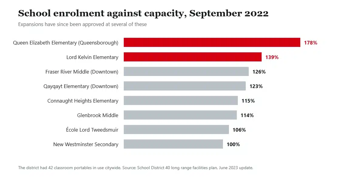
School District 40 had 7,258 domestic students in September 2022 and 42 classroom portables in use. Its long-range plan projects a shortfall of 2,241 spaces by 2037 without new capacity, and notes that eleven of its twelve school sites fall below the provincial standard for site area.
The pressure is not spread evenly, which is the useful part for anyone choosing a street. Queen Elizabeth Elementary in Queensborough was running at roughly 178 per cent of capacity with eight portables. Lord Kelvin was at 139 per cent, also with eight. Qayqayt downtown was at 123 and Fraser River Middle at 126. New Westminster Secondary, replaced in January 2021 at a cost of $106.5 million, was sitting exactly at capacity.
Work is in train. That Queensborough school was approved for a 303-seat expansion, Skwo:wech in Sapperton gained 95 seats through its seismic replacement, and a new 565-seat elementary is planned. Some of those target dates have now passed, so check the current position with the district rather than taking a 2023 plan at face value.
French immersion runs early at École Herbert Spencer and École Lord Tweedsmuir, late from grade six at École Glenbrook Middle, and both streams merge in grade eight and continue at New Westminster Secondary.
Water, trains and the hill
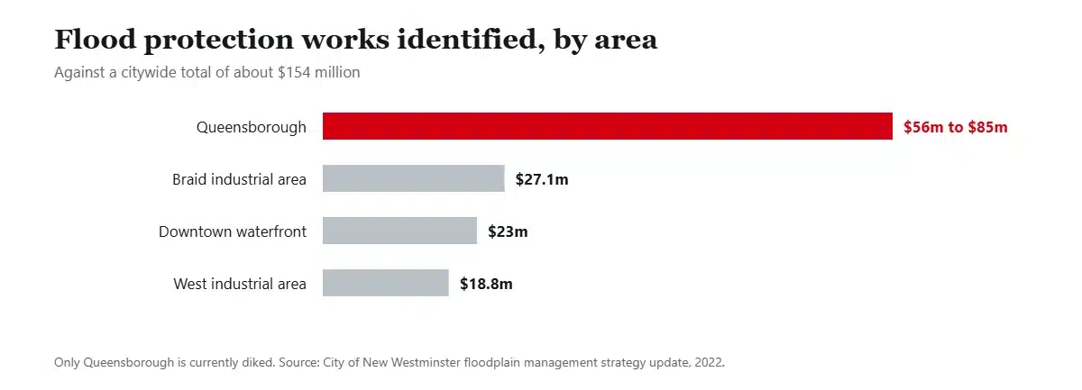
There are about 12.6 kilometres of dikes and they are all around Queensborough. The mainland floodplain, roughly 170 hectares taking in the downtown waterfront, the Braid industrial area and the west industrial area, is not diked at all, and the city’s own strategy calls those areas increasingly vulnerable as development intensifies. No construction timeline is attached to any of it.
Which puts flood risk squarely on the low ground. Uptown, Queen’s Park, the Glenbrookes, Moody Park, Connaught Heights and Massey Victory Heights are on the hill and out of it.
Trains are the other neighbourhood-level difference, and here the city publishes crossing-by-crossing detail that no listicle has. Queensborough has eleven rail crossings, the mainland and Sapperton twelve between them, and the West End two. Whistle cessation is complete at a handful, mostly downtown. Braid Street’s crossings were scheduled for 2026, Spruce Street at Brunette is a 2027 question, one West End crossing is targeted for late 2026 and another has no date at all, and five Queensborough crossings along Ewen Avenue are still at options-study stage. A freight whistle is required to reach 96 decibels at 30 metres.
As for the hill, which shapes everything about how this city feels, one honest correction. There is no steep-slope or hazardous-slope development permit area anywhere on the New Westminster mainland. The only natural hazard permit area in the city is the Queensborough floodplain. So the grade here is a matter of views, walkability and how hard your legs work, and anyone telling you about landslide risk in New Westminster is not quoting the city.
Frequently asked questions
What is the nicest neighbourhood in New Westminster?
Depends what you are optimising for. Historic houses point to Queen’s Park, walkability and transit to Downtown, older character near two stations to Sapperton, a house on the hill to Glenbrooke North or Massey Victory Heights, and newer stock with river frontage to Queensborough.
Is Queensborough part of New Westminster?
Yes, it is a full part of the city with its own community plan and residents’ association. The place is just physically on Lulu Island, across the Fraser from the rest of New Westminster and next to Richmond, and it has no SkyTrain.
Can I renovate a house in Queen’s Park?
Inside the heritage conservation area, a house built in 1940 or earlier needs a heritage alteration permit to change its front or sides, to add floor space, to alter windows and doors, to change a roof form visible from the street, or to subdivide. Newer houses need one to build new, to add a detached accessory dwelling, or to subdivide.
Which New Westminster neighbourhood has the best transit?
Downtown, with two stations inside it. Sapperton also has two. Uptown is the dense area without one, which is why the city is designating it a frequent transit development area instead.
Where is the cheapest place to buy in New Westminster?
Nobody publishes prices by neighbourhood, so any specific answer is a guess. What is published is the municipal picture: an apartment benchmark of $576,100, a townhouse benchmark of $873,400 and a detached benchmark of $1,377,600 in August 2026.
How we put this together
Area names and planning status come from the City of New Westminster’s own official community plan maps, area plans, bylaws, development permit area schedule and heritage documents. Growth and housing target figures come from the city’s provincial reporting, prices from Greater Vancouver Realtors, schools from School District 40, transit from TransLink, and flood, rail and heritage information from the city’s own engineering and planning documents.
Four things we would not do. No neighbourhood-level prices appear here, because no primary source publishes them. We have not given current neighbourhood populations, because the city’s neighbourhood profile series stopped at the 2006 census. We have not assigned a transit-oriented tier to any station, because the city publishes the bands but not the assignments. And we have not written a character description for Brow of the Hill, because the city has not published one and we are not going to invent it.
Sources
- City of New Westminster, Our City 2041 Official Community Plan
- City of New Westminster, statistical planning boundaries map
- City of New Westminster, residents’ associations
- City of New Westminster, Queensborough Community Plan
- City of New Westminster, building in Queensborough
- City of New Westminster, Queen’s Park Heritage Conservation Area guide
- City of New Westminster, how the heritage conservation area was developed
- City of New Westminster, infill housing program
- City of New Westminster, transit-oriented development areas
- City of New Westminster, housing target order
- City of New Westminster, floodplain management strategy update, 2022
- City of New Westminster, railways and whistle cessation
- School District 40, long range facilities plan
- Pattullo Bridge Replacement Project, current works
- Greater Vancouver Realtors MLS Home Price Index statistics
Narrowed it down to a shortlist? Our cost breakdown prices out tax, utilities and the commute, the crime numbers deal with the question most people ask next, and the wider case for and against weighs the whole thing up. When you have picked a street, tell us where you are moving from.
