

Last updated: August 2026 · Every area below is sourced to a City plan or marked as informal local usage
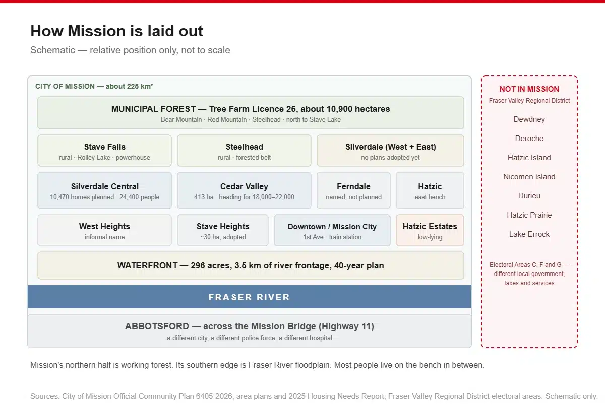
Mission is about 225 square kilometres of river flats, benchland and forested mountain, and it does not have tidy neighbourhoods the way a planned suburb does.
What it has is a handful of formally planned areas with adopted bylaws behind them, a set of names the City itself uses in its documents, a set of names only locals and realtors use, and (this is the part that trips people up) a ring of nearby communities that are not in Mission at all.
Here is the honest map.
First: what is and isn’t Mission
If you are house-hunting on a listings site, you will see Dewdney, Deroche, Durieu, Hatzic Prairie and Lake Errock filed under “Mission.” None of them are in the City of Mission.
| Place | Actually in |
|---|---|
| Dewdney | FVRD Electoral Area G |
| Deroche | FVRD Electoral Area G |
| Hatzic Island | FVRD Electoral Area G |
| Nicomen Island | FVRD Electoral Area G |
| Durieu | FVRD Electoral Area F |
| Hatzic Prairie | FVRD Electoral Area F |
| Lake Errock | FVRD Electoral Area C — 28 km east of Mission |
Source: Fraser Valley Regional District electoral area pages.
This is not pedantry. A different local government means different property taxes, different servicing, different bylaws and often no municipal water or sewer. Buying in Deroche is not buying in Mission.
Two things make the confusion easy. School District 75 is called “Mission” and covers a much larger area than the municipality. Deroche Elementary and Dewdney Elementary are Mission-district schools in communities outside the city. And Dewdney Trunk Road runs right through Mission, which is not the same as the community of Dewdney.
The officially planned areas
These have adopted plans and defined boundaries. Mission’s current Official Community Plan is Bylaw 6405-2026, adopted 1 June 2026.
Downtown Mission (Mission City)
The historic core, immediately north of and above the river. The City’s own plan describes “small connected blocks, narrow storefronts and diverse ownership”, an area bounded roughly by Grand, Horne, Murray and James Streets, with 1st Avenue as the retail spine.
Mission City station, the West Coast Express terminus, sits at its east end, and the OCP designates the area around it as a Transit Oriented Area with the city’s highest permitted densities.
The honest note: the City’s own 2013 downtown action plan cited declining retail, limited pedestrian amenity and insufficient residential density, and Highway 7 traffic runs straight through. That plan is now thirteen years old.
Suits: anyone who wants to walk to the train, and who would rather live somewhere with a real main street than a subdivision.
The Waterfront
296 acres with 3.5 km of Fraser River frontage, between Mission Raceway and the CP Rail bridge, directly south of downtown. This is the largest undeveloped river frontage in the Lower Mainland.
Today it is industrial and vacant. The adopted Waterfront Revitalization Master Plan is a 40-year proposition for mixed-use, employment and restored natural areas. Implementation so far has been infrastructure: raising land around the Mission Bridge, and design work on the Lane Creek pump station and east end dike.
Suits: nobody yet. Worth watching if you are thinking in decades.
Cedar Valley
Mission’s principal urban growth area and where most new family housing is going. 413 hectares on the bench north of downtown, bounded west by the Silverdale Creek ravine, north by Dewdney Trunk Road, east by Ferndale Institution and Harms Street, and south by Cherry Avenue.
Population was about 7,900 in 2016 and the adopted Local Area Plan projects 18,000 to 22,000 at build-out. Everything is new or under construction.
Albert McMahon Elementary is the only elementary school in Cedar Valley, with two more proposed in later phases, a familiar Fraser Valley pattern where housing arrives before schools do. Parks: Lightburn, Tom Jones, Griner. Protected creek corridors run through it: Silverdale, Cherry, Nicholson, Gaudin and Ammon Brook.
Suits: families who want new build and a yard, and don’t mind living beside construction for a few more years.
Silverdale
The long game. The Silverdale Comprehensive Planning Area is 1,392 hectares (3,440 acres), the largest planning area in the city. It sits west of downtown on the east bank of the Stave River where it meets the Fraser.
Only the Central Neighbourhood has an adopted plan, and it is substantial: 10,470 homes for about 24,400 people, on city water and sewer. A development permit for the first 163-unit townhouse complex at Loftus Village was approved in April 2026, the first of six planned there. Trunk infrastructure is expected between 2026 and 2028.
The West and East Neighbourhoods have no plans yet. They are earmarked for industrial, employment and large outdoor sports facilities, but nothing is written. Marketing material sometimes blurs this; only Central is adopted.
Today the area is still semi-rural, with Silverdale Elementary, the Silverdale Industrial Park and lakeshore homes on Silvermere Lake.
Suits: buyers who want brand-new and are comfortable being early. Read the flood section before you buy near the water here.
Stave Heights
Small and specific, about 30 hectares on the hillside above Fraser River Heritage Park and east of Stave Lake Street, just northeast of downtown. The neighbourhood plan, adopted 16 May 2022, describes an environmentally sensitive hillside with trails and protected natural land.
Suits: buyers who want a hillside lot close to the centre.
The Health and Wellness District
Named in the adopted OCP as an emerging employment hub, with an area plan in progress through 2026. Its boundaries have not been published yet, so we are not going to tell you where it is.
Areas the City names but hasn’t planned
These appear in the City’s own 2025 Housing Needs Report and Rural Mission Strategy as distinct communities, but have no neighbourhood plan or published boundary.
Hatzic
Established residential on the east side of Mission, on benchland overlooking the Hatzic floodplain. Served by Hatzic Elementary and Hatzic Middle School. Hatzic Lake, an oxbow of the Fraser, lies north and east.
Note that “Hatzic” straddles the municipal boundary: the bench neighbourhood is in Mission, while Hatzic Island, Hatzic Prairie and Hatzic Valley are Fraser Valley Regional District.
The City’s own flood plan calls out Hatzic Estates as “very low areas” prone to standing water, and notes the Fraser runs about half a metre higher at Hatzic Slough than at the Mission gauge.
Stave Falls
Rural northwestern Mission, well back from the Fraser and bordered by the Stave River, the south end of Stave Lake, the Maple Ridge boundary and Ruskin Dam. Has its own elementary school. The landmarks are the Stave Falls Dam and Powerhouse, a National Historic Site with a visitor centre, and Rolley Lake Provincial Park (64 campsites) about 23 km northwest.
Suits: people who want acreage and are content to drive for everything.
Steelhead
In the northern forested belt, alongside Bear Mountain and Red Mountain within the Municipal Forest. Its school catchment moved from Albert McMahon to Stave Falls Elementary in the 2021–22 boundary review. Rural.
Ferndale, Keystone and Mission Core
All three are named as areas in the City’s 2025 Housing Needs Report. Ferndale’s landmark is Ferndale Institution, a federal minimum-security facility east of Cedar Valley. Beyond that, we could not find a sourced description of the housing stock or character of any of the three, so we are naming them and stopping there rather than inventing a description.
Names you’ll hear that aren’t official
These are real place names with no official boundary behind them:
- West Heights is the area around West Heights Community Elementary
- Cherry Hill, anchored on Cherry Hill Elementary; Cherry Avenue is Cedar Valley’s southern boundary
- Hillside sits around Hillside Traditional Academy, though that is a district-wide school of choice rather than a catchment school, so it doesn’t define an area
- College Heights. The City classifies this as a trail at Weatherhead Court, not a neighbourhood. Realtors use the name for the surrounding area; the City does not
- Ruskin is a genuinely split community at Mission’s southwest corner where the Stave meets the Fraser, half in Maple Ridge and half in Mission. Ruskin Dam created Hayward Lake
Flood risk — read this before you buy
Mission sits on the north bank of the Fraser, and parts of it are floodplain. This is documented in detail by the City, and it should shape where you look.
The dikes
- Mission Dike: protects the largest developed area. Design elevation 9.5 m above sea level including 0.6 m of freeboard. Meets current provincial standards except at parts of the upstream end and the furthest downstream point.
- Silverdale Dike: built to a lesser agricultural standard and still at its pre-2007 protection elevation.
- Dewdney Dike: protects the Hatzic Lake area, administered outside the City.
Properties in the Mission and Silverdale diking areas pay an additional levy of 0.09234 per $1,000 of assessed value on top of the regular tax rate.
Areas the City names as unprotected or low-lying
| Area | Status per the City’s flood plan |
|---|---|
| Silvermere Lake foreshore | Residential, no dike |
| Ruskin Trailer Park | No dike; water reaches trailer skirting |
| Silverdale Industrial Park | No dike; access problems above 6.0 m |
| Hatzic Estates | Very low; prone to standing water |
| Triple Creek Estates | Becomes isolated at higher river levels |
The City publishes response thresholds against the Mission gauge at the CP Rail bridge: the river is within its natural banks below 5.5 m, at the top of them at 5.5 m, spilling onto unprotected floodplain at 6.0 m, flooding Silvermere yards at 6.4–6.5 m, and within 1.5–2.5 m of the dike crest above 7.0 m.
The City’s public map viewer carries a floodplain mapping layer with flood construction levels, setbacks and dike alignments. That is the tool to use for a specific address, and it is free.
Farmland and forest
About 1,539 hectares of Mission is in the Agricultural Land Reserve, roughly 7% of the municipality, although that figure comes from a 2011 provincial survey published in 2013 and is now dated.
The bigger land story is the Mission Municipal Forest. Tree Farm Licence 26, granted in 1958, covers about 10,900 hectares across Bear Mountain, Red Mountain and Steelhead, extending north of Stave Falls along the western shore of Stave Lake. The City directly owns about 11–12% of it; the rest is provincial Crown land. The annual allowable cut is 60,000 m³, and revenue goes to a forestry reserve fund for community projects.
Practically: Mission’s northern half is working forest and is going to stay that way.
Schools, by area
School District 75 runs 19 sites (13 elementary, 2 middle, 1 secondary and 3 alternate, online or college programmes) for 6,577 students in 2025/26.
There is one mainstream secondary school in the entire district: École Mission Secondary. Wherever you buy, that is where your teenager goes.
On the Fraser Institute’s 2025 elementary report card, the rated Mission schools were:
| School | Rating out of 10 | Five-year average |
|---|---|---|
| Hillside Traditional Academy | 6.8 | 6.2 |
| Christine Morrison | 3.8 | 4.0 |
| Hatzic | 2.6 | 3.6 |
| Albert McMahon | 2.6 | 3.1 |
Read those with the usual caution. It is an advocacy organisation’s ranking built on standardised test data from 2023/24, and it measures a narrow slice of what a school does. Note also that Hillside is a district-wide school of choice, not a catchment school, so buying near it does not get you in.
The district does not publish a catchment map. It directs families to an address-based school locator, which is the only reliable way to find out which school serves a specific house.
The short version
| If you want… | Look at |
|---|---|
| To walk to the Vancouver train | Downtown Mission |
| New build and a family street | Cedar Valley |
| Brand new, and you’re comfortable being early | Silverdale Central |
| A hillside lot near the centre | Stave Heights |
| Established housing on the east side | Hatzic bench |
| Acreage, lakes and forest | Stave Falls, Steelhead |
| The lowest prices | Look outside the City — but understand you’re leaving it |
| To avoid floodplain entirely | The benchland: Cedar Valley, Stave Heights, Hatzic bench |
Frequently asked questions
What are the best neighbourhoods in Mission BC?
Cedar Valley has the newest family housing and an adopted plan behind it. Downtown puts you within walking distance of the West Coast Express. Stave Falls and Steelhead are the rural options. “Best” depends on whether you are optimising for the commute, a new house or land.
Is Dewdney part of Mission?
No. Dewdney, Deroche, Hatzic Island and Nicomen Island are in Fraser Valley Regional District Electoral Area G. Durieu and Hatzic Prairie are in Electoral Area F. They are outside the City of Mission, with different local government and services, even though several are served by Mission’s school district.
Which parts of Mission flood?
The City names Silvermere Lake foreshore, Ruskin Trailer Park and Silverdale Industrial Park as undiked, and Hatzic Estates and Triple Creek Estates as low-lying or vulnerable to isolation. The Mission and Silverdale dikes protect the main developed areas, though the Silverdale dike is built to a lesser agricultural standard. Check a specific address on the City’s floodplain mapping layer.
Where is Mission’s growth happening?
Cedar Valley in the short term: 413 hectares heading for 18,000 to 22,000 residents. Silverdale in the longer term: the adopted Central Neighbourhood plan alone provides for 10,470 homes and about 24,400 people.
How many secondary schools does Mission have?
One mainstream public secondary school, École Mission Secondary, plus two middle schools and alternate, online and college programmes.
Sources
- City of Mission — Official Community Plan (Bylaw 6405-2026)
- City of Mission — Cedar Valley Local Area Plan
- City of Mission — Silverdale Central Neighbourhood Plan
- City of Mission — Stave Heights Neighbourhood Plan
- City of Mission — Waterfront Revitalization Master Plan
- City of Mission — Fraser River Flood Preparedness and Response Plan
- City of Mission — Municipal Forest and Tree Farm Licence 26
- City of Mission — Housing Needs Report 2025
- Fraser Valley Regional District — Electoral Area G
- School District 75 — schools
- Fraser Institute — BC elementary schools report card 2025
Once you’ve picked the area, we’ll handle the boxes — here’s how we move people around Mission.
