

Last updated: August 2026
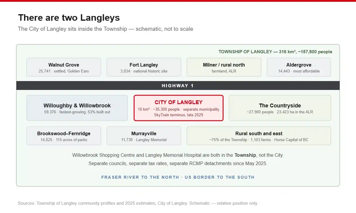
Before anything else, the thing that confuses everyone: there are two Langleys.
The City of Langley is about 10 square kilometres, urban, and contains downtown Langley. Roughly 35,000 people.
The Township of Langley wraps around it: 316 square kilometres, about 158,000 people, and it contains Walnut Grove, Willoughby, Fort Langley, Murrayville, Brookswood-Fernridge, Aldergrove and a big rural area.
They are separate municipalities with separate councils, separate police detachments and separate tax rates. Willowbrook Shopping Centre, which most people would call “in Langley City,” is actually in the Township. Langley Memorial Hospital is in the Township too.
If you take one thing from this article, take that. It affects your property tax bill, your policing, and which council meeting to go shout at.
Now, the neighbourhoods.
Population by community
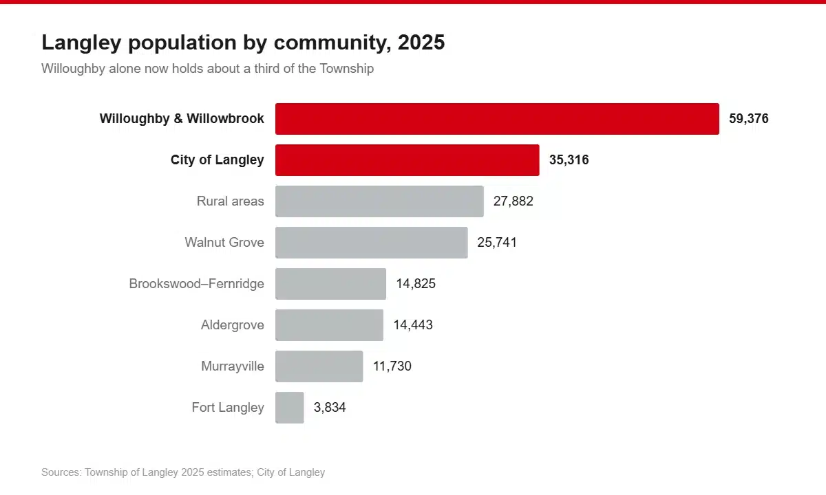
Township estimates, 2025:
| Community | Population |
|---|---|
| Willoughby & Willowbrook | 59,376 |
| Rural areas | 27,882 |
| Walnut Grove | 25,741 |
| Brookswood-Fernridge | 14,825 |
| Aldergrove | 14,443 |
| Murrayville | 11,730 |
| Fort Langley | 3,834 |
| City of Langley (separate municipality) | ~35,316 |
The income and employment figures below come from the Township’s own community profiles, which are built on 2016 census data, the most recent community-level breakdown the Township publishes. Treat them as relative rather than current.
Willoughby–Willowbrook
The one that’s changing fastest, by a distance.
Willoughby had 2,197 people in 1991. It had 11,710 in 2011. It has around 59,000 now. It went from about 3% of the Township’s population to roughly 30% in thirty-five years, and it’s only 53% built out. The Township’s own community plan projects an eventual population between 87,000 and 107,000.
That gives you the texture of the place. Everything is new. Townhouse rows, six-storey wood-frame apartments, wide arterials, roundabouts, and construction hoarding that moves around but never leaves.
It also has the youngest profile in the Township: the largest age cohort is 30 to 34, the highest labour force participation at 71.2%, and the most varied housing stock in Langley: detached, townhomes, condos and suites, plus surviving rural lots and hobby farms that haven’t been developed yet.
What’s here: the Langley Events Centre, home of the WHL’s Vancouver Giants. Willowbrook Shopping Centre. Willowbrook Recreation Centre. Carvolth Exchange, the park-and-ride and bus exchange that connects to SkyTrain and the West Coast Express. R.E. Mountain Secondary.
The catch: growth has outrun services and residents say so loudly. Around 6,000 housing units were approved in the Willoughby/200th Street corridor from 2022, with proposals for a further 1,400 and 2,000 units on top. The Township gains roughly 1,000 new students a year, most of them here. The mayor said publicly in 2024, “We are not seeing schools built fast enough by the provincial government,” and “Potentially we are seeing too much growth too quickly.” Council responded by phasing development, and says the growth rate has since dropped about 30%.
The upside nobody’s pricing in yet: the Surrey Langley SkyTrain terminates nearby in late 2029.
Suits: first-time buyers, young families, anyone who wants new construction and doesn’t mind living on a building site for a few more years.
Walnut Grove
The settled one.
Built out largely through the 1980s and 90s as a master-planned suburb, and it shows in a good way: curved streets, mature trees, consistent housing stock, mostly detached with some multi-family. Population’s been roughly stable for a decade, which in Langley terms makes it the anti-Willoughby.
Median household income was the second-highest in the Township at $111,065 in 2016, and the largest age cohort is 45 to 49. This is where people who bought in the 90s stayed.
What’s here: Walnut Grove Community Centre, with an indoor leisure pool and waterslide, a fitness centre, and a community park next door with a skate park, spray park and playing fields. A 19-screen Cineplex. Walnut Grove Secondary, one of SD35’s better-known schools.
The location advantage: it sits against Highway 1 with direct access to the Golden Ears Bridge, which puts Maple Ridge and Pitt Meadows within easy reach, genuinely useful if work is north of the Fraser.
Suits: families who want a finished neighbourhood rather than one being built around them, and anyone commuting north.
Fort Langley
The pretty one, and the expensive one.
Population 3,834. It has the highest median household income of any Langley community: $126,721 in 2016, with 30% of households above $150,000, and the lowest unemployment, 1.6%. It also has the oldest age profile, with the largest cohort aged 65 to 74.
The village sits on the Fraser River with a boardwalk of shops, galleries and restaurants, a restored CN station, and the Langley Centennial Museum. Housing is overwhelmingly detached and very little of it comes up.
The history is real, not marketing. Fort Langley National Historic Site was a Hudson’s Bay Company fur trade post established in 1827, and on 19 November 1858 Governor James Douglas proclaimed the Colony of British Columbia there, which is why the Township calls itself the Birthplace of BC. It was designated a national historic site in 1923. You can walk the palisade, tour the fur-trade buildings and the heritage farm, and there’s oTENTik accommodation inside the walls.
What’s here: the Fort-to-Fort Trail, golf, rowing, an outdoor pool, camping. Cranberry Festival, Jazz & Arts Festival, and a Canada Day that takes over the village.
The catch: small, tightly held, and priced accordingly. It’s also a tourist destination, so summer weekends are busy in a way residents have feelings about.
Suits: buyers who want a village rather than a subdivision and can afford the entry price.
Murrayville
The historic, institutional one.
About 11,730 people, organised around a distinctive five-corner intersection and historic Old Yale Road, with the Murrayville Community Hall dating from 1928. Median household income was $98,947 in 2016.
It has the oldest age profile of any Langley community: the largest single cohort is residents aged 75 and over, at 1,360 people. That’s partly because Langley Memorial Hospital is here, and the healthcare and seniors’ infrastructure clusters around it.
What’s here: the hospital. McLeod Athletic Park, with a full running track and multi-sport fields. W.C. Blair Recreation Centre with a swimming pool and wave pool.
Suits: downsizers, retirees, anyone who wants to be near the hospital, and families who like a neighbourhood with some actual history to it.
Brookswood–Fernridge
The one that hasn’t changed.
Population 12,820 in 2016, and 13,090 in 2001. It is the only Langley community that has been essentially flat for twenty years, which in this municipality is remarkable.
It’s really two places. The northern half was built between the 1960s and 1990s: large single-family lots on treed streets, a few commercial pockets. The southern half is still suburban lots, farms, manufactured home parks and vacant land, planned for future mixed-use development that hasn’t arrived.
Average household income was $119,571 in 2015, though note that’s an average, where the other communities’ figures quoted here are medians, so don’t rank them against each other. The median age cohort is 55 to 59. Construction is the largest employment sector here, at 1,060 workers.
What’s here: 115 acres of public park space, the most park-per-resident of any Langley community. A spray park, BMX track, disc golf course and skate park. George Preston Recreation Centre with ice arenas. Brookswood Secondary.
Suits: people who want a big treed lot and are actively avoiding the Willoughby experience. Also anyone with a kid in hockey.
Aldergrove
The most affordable, and the most industrial.
Population 14,443, and one of only two Langley communities that hasn’t grown. Median household income was $85,368 in 2016, the lowest of the profiled communities, and it has the highest agricultural employment share at 5% of the labour force.
It sits at Highway 1 Exit 73, right by the Lynden/Aldergrove US border crossing, and it’s a genuinely mixed urban-rural community rather than a suburb.
What’s here: the Aldergrove Credit Union Community Centre, with a 500-seat NHL-sized ice arena, pools, a gym and a waterpark. Aldergrove Regional Park. The Greater Vancouver Zoo. The Twilight Drive-In, which is exactly what it sounds like. Aldergrove Community Secondary.
The jobs: Gloucester Industrial Estates sits at Aldergrove’s northeast corner with direct border access. GM, Kenworth, Freybe and Cascadia Windows & Doors are among the employers the Township names there. A long-requested bus route to Gloucester was reported as starting in September 2026, and a further industrial complex was proposed in July 2026.
Suits: buyers priced out of the rest of Langley, people who work in the industrial park, and cross-border commuters.
The Countryside (the rural Township)
Three quarters of Langley, and almost nobody talks about it.
About 27,882 people spread across the rural area, which covers roughly 75% of the municipality and sits almost entirely inside the Agricultural Land Reserve. 23,423 hectares are in the ALR, about 235 of the Township’s 316 square kilometres. It is not going to be developed.
Lot sizes tell you what it is: 48.7% of properties are between 1.7 and 7.5 hectares, 37% under 1.7 hectares. Minimum lot sizes are 8 hectares in the Agriculture and Countryside zones, 1.7 in Small Farms and Country Estates.
Agriculture here is serious business. The Township has 1,103 farms working 10,807 hectares, with $340 million in gross farm receipts, third highest of any BC municipality and the highest in Metro Vancouver. Dairy, berries, poultry and eggs, greenhouse and nursery, beef, mushrooms. And horses: the Township is known as the Horse Capital of BC.
Commercial services are deliberately limited: small nodes at Milner and at 232 Street and Fraser Highway, plus an agro-service centre at 248 Street, all with restricted expansion to protect the rural character.
Suits: acreage buyers, horse people, farmers, and anyone who wants land inside Metro Vancouver, which is a genuinely rare thing.
Langley City
The urban core, and the one with a reputation problem.
Roughly 35,316 people in 10 square kilometres, with over 346 acres of parkland. Separate municipality. It contains downtown Langley, Cascades Casino, and the pedestrian-oriented core the City has been working to build up. Kwantlen Polytechnic University has a campus nearby.
It is also growing fast, about 20% between 2020 and 2024, and 5% in 2023–24 alone, which made it BC’s second-fastest-growing municipality over 30,000 that year.
The big one: the Surrey Langley SkyTrain terminates here. Two of the eight new stations are in Langley City: Willowbrook at 196 Street and Langley City Centre at 203 Street, which will be a transit exchange. Sixteen kilometres of elevated guideway along Fraser Highway, $5.996 billion, opening late 2029. Projected trip time from Langley City Centre to King George Station: about 22 minutes, more than 25 minutes faster than the bus today.
The reputation: Langley City’s Crime Severity Index was 137.8 in 2025, well above BC’s 92.4. Read our piece on whether Langley is safe for the full picture, but the short version is that a 10-square-kilometre town centre absorbs the crime generated by a regional catchment many times its residential population: the shopping, the transit exchange, the casino, the hospital catchment and the supportive housing all sit inside those 10 km². Crime is counted where it happens, not where people live. The City’s own crime rate fell every single year from 2019 to 2023, by 33.7%.
Suits: buyers who want the lowest entry price in Langley, anyone positioning for SkyTrain, and people who want to be able to walk somewhere.
The short version
| If you want… | Look at |
|---|---|
| New build, best value, future SkyTrain | Willoughby, Langley City |
| A finished, settled neighbourhood | Walnut Grove |
| A village with history | Fort Langley |
| Near the hospital, quieter, older | Murrayville |
| A big treed lot and parks | Brookswood-Fernridge |
| Lowest prices, industrial jobs | Aldergrove |
| Land, horses, farming | The rural Township |
| Walkable, cheapest entry, transit coming | Langley City |
| Commuting north over the Golden Ears | Walnut Grove |
| Commuting to Surrey and Vancouver | Willoughby (Carvolth), Langley City |
Schools
School District 35 covers both municipalities: 26,943 students in 2025/26 across 46 school sites, with nearly 5,000 employees and a $463.3 million budget. Seven secondary schools serve the district: Aldergrove Community, Brookswood, D.W. Poppy, Langley Secondary, Langley Fundamental, R.E. Mountain and Walnut Grove.
On the Fraser Institute’s 2025 elementary report card, the top-rated Langley schools were St. Catherine’s (independent, 9.7), Alex Hope (8.3) and Langley Christian (independent, 7.6), followed by Topham, Langley Fine Arts, Langley Fundamental and Willoughby all at 6.8.
Caveat as always: that’s an advocacy organisation’s ranking built on standardised test results from 2023/24, and it has not published a BC secondary school report card since 2020.
Trinity Western University is in the Township, with about 5,000 students from more than 80 countries, 48 undergraduate and 19 graduate degrees, founded 1962.
Frequently asked questions
What’s the difference between Langley City and Langley Township?
They’re two separate municipalities. The City is about 10 km² with roughly 35,000 people and contains downtown Langley. The Township is 316 km² with about 158,000 people and contains Walnut Grove, Willoughby, Fort Langley, Murrayville, Brookswood, Aldergrove and the rural area. Separate councils, separate tax rates, separate RCMP detachments since May 2025.
Which is the best neighbourhood in Langley?
Depends what you’re optimising for. Fort Langley has the highest incomes and the most character. Walnut Grove is the most settled family option. Willoughby has the newest housing and the SkyTrain coming. Brookswood has the most parkland. Aldergrove is the most affordable.
Where is Willowbrook Mall — City or Township?
Township. This trips up almost everyone.
Is Willoughby a good place to buy?
It has the newest stock, the widest range of housing types and a SkyTrain station arriving in late 2029. The trade is that it’s still a construction zone, only about half built out, and schools have not kept pace with the growth, and the Township has said so publicly.
When does the SkyTrain reach Langley?
Late 2029. Sixteen kilometres from King George Station in Surrey to 203 Street in Langley City, eight stations, $5.996 billion. As of May 2026 all eight stations were under construction and about 5 km of elevated guideway was installed.
Moving into one of these? Our Langley movers know the difference between a Willoughby townhouse elevator booking and a Fort Langley heritage staircase.
